
The Old Federal Road
- Profile
- Images
Location: Georgia to Alabama


written by Allan Thomas
Contents |
The Old Federal Road

|
| Embryo Town of Columbus on the Chatahoochie |
From its start as a narrow horse path used to carry the mails, the Old Federal Road underwent great development and became a major military road connecting early American forts in the Creek Lands and the Mississippi Territory. Acting as the interstate highway of its day, when “Alabama Fever” raged through the Carolinas and Georgia, the Old Federal Road carried thousands of pioneers to the Old Southwest.
The Federal Road became a well traveled stagecoach route for those going through Alabama. In 1824, Adam Hodgson wrote Letters from North America Written During a Tour in the United States and Canada wherein he described his 1820 travel along the Federal Road from Chattahoochee to Mobile. Hodgson found adequate over-night lodgings, he concluded that “the road, which is called the Federal Road, though tolerable for horses, would with us be considered impossible for wheels.”
Nearly two centuries later, the Federal Road remains visible. In 2010 the Old Federal Road was named a “Place in Peril” by the Alabama Historical Commission and Alabama Trust for Historic Preservation. Its placement on the list of “Alabama’s Most Endangered Sites for 2010” highlighted the road as one of Alabama’s most significant endangered historic places and raised awareness across the state. [1]

|
| Old Federal Road and its major branches in Alabama, |
1800
1800- the Lower Creek Trading Path, formed the basis for the Garrison Road, which was completed across the southern part of Jones County Georgia just before the county was organized. The path was formally known as the Chelucconeneauhasse or Old Horse Path. It led westward from Augusta via the Rock Landing on the Oconee, present Macon on the Ocmulgee, and the site of the old Indian Agency on the Flint (in western Crawford County) to the Creek towns on the Chatthoochee below today's Columbus. It was one of the historic Indian trading routes of the country and was used by Carolina traders before the foundation of Georgia. This military thoroughfare would become a segment of the Federal Road linking Washington, D.C., with New Orleans, Louisiana.
This road was built about 1800 by the State of Georgia as a military road for the movement of troops between Milledgeville and Fort Hawkins (Macon) during the Indian Wars. It was strongly garrisoned to afford protection on the east side of the Ocmulgee River.
The Old Horse Path developed into the "Federal Road".[2]
Following the Louisiana Purchase in 1803, President Thomas Jefferson and his Indian Agent to the Creeks, Benjamin Hawkins, negotiated official use of the trail as a Federal Road and it became a conduit for white settlement in southwest Georgia, Alabama, Mississippi and Louisiana.
Isaac Briggs and assistant Thomas Robertson left Washington City in July 1804. Briggs was commissioned by Thomas Jefferson as the Surveyor General for the Louisiana Purchase. They had offered President Jefferson to create a map for the post road to New Orleans. They proceeded to General David Merriwether's home, near Athens, Ga., arriving near the eastern boundary of Indian Lands September the 6th, 1804. On to Col. Hawkins's place on the east bank of the Flint River at Roberta, Crawford County, Ga.. Then to Col. Hawkins's place "Point Comfort" near the Tallapoosa River. Point Comfort’s location is uncertain. Seven days later they crossed the Chattahoochee. On 10-03-1804 they left the Chattahoochee and they arrived at the home of Nathaniel Christmas (about two miles above the confluence of the Chattahoochee and Alabama Rivers, about 4 miles northeast of Fort Stoddert. After a two week delay Briggs moved then south on the Mobile and across to New Orleans. Arriving in New Orleans four months after leaving Washington. Considering the hardships Briggs and Robertson endured, their surveying accomplishments offered slim returns.
Briggs’s main accomplishment was his demonstration that a mail route across the Creek Nation could cut about 500 miles off the post route in comparison with the trans-Appalachian/Natchez Trace route then in use. Jefferson seems to have been blind to the difficulties Briggs encountered on his journey. Settlers who obtained passports across the Creek Nation would find the obstacles Briggs described to be very real, the major obstacle being the Creeks themselves.
1805
By sweetening the deal for Creek leaders who signed for their people,stipulating the chiefs as responsible for building and operating causeways, ferries, and “houses of entertainment” along the horse paths, chiefs were sure to benefit handsomely from tolls, lodging fares, and tavern tabs. The expected profits were so great that several Creek leaders tried to change the route in places to bring traffic closer to their residences.
- ARTICLE 2. It is hereby stipulated and agreed, on the part of the Creek nation that the government of the United States shall forever hereafter have a right to a horse path, through the Creek country, from the Ocmulgee to the Mobile, in such direction as shall, by the President of the United States, be considered most convenient, and to clear out the same, and lay logs over the creeks: And the citizens of said States, shall at all times have a right to pass peaceably on said path, under regulation and such restrictions, as the government of the United States shall from time to time direct; and the Creek chiefs will have boats kept at the several rivers for the conveyance of men and horses, and houses of entertainment established at suitable places on said path for the accommodation of travelers; and the respective ferriages and prices of entertainment for men and horses, shall be regulated by the present agent, Col. Hawkins, or by his successor in office, or as is usual among white people.
1806
In 1806 Postmaster General Gideon Granger contracted with Joseph Wheaton who oversaw the clearing of a horse path running from Athens to Fort Stoddert, north of Mobile, Alabama, and then on to New Orleans, Louisiana.
Wheaton’s contract required him to open a 4-foot wide bridle path or horse road, to span all swampy places with “causeways,” to fell trees as foot bridges across narrow streams, and to encourage Indians to establish ferries at larger stream and river crossings
The horse path for postal riders was opened through the Creek Nation. As the likelihood of another battle with Britain increased, the crucial need to quickly move troops to protect the American Gulf Coast was becoming more evident.
A regular mail route was eventually established through the Creek Nation due to the persistence of Benjamin Hawkins. After Wheaton’s effort failed to open a path, Hawkins worked with the U.S. military to make the route passable for horses, hired Creek Indians as post riders, and encouraged the Creeks to establish along the route those “houses of entertainment” called for in the treaty.
- William McIntosh tavern at Coweta
- Samuel Moniac tavern at Pintlala
- James Cornells at Burnt Corn Springs
1810

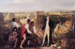
|
| Chiefs of the Creek Nation and a Georgia Squatter |
When Samuel Bloomfield, one of Wheaton’s former subcontractors, “entered with his waggon and team and commenced and built bridges” in 1810 on the upper path, the Creek National Council voiced a valid objection that the Treaty of 1805 allowed only ferries across streams and logs over creeks, not bridges, which cut into the profits Indians could derive themselves from ferry traffic and toll bridges along the path.[3]
In June 1810, Fort Stoddert's commanding officer Col. Richard Sparks was ordered by Secretary of War William Eustis to inspect and document these horse paths in order to mark a military road so that troops and supplies could be sent to defend the Gulf Coast.
The Federal Road directly contributed to the dramatic increase in Alabama’s population between 1810 and 1820 - with Alabama’s population growing far faster than that of either Mississippi or Louisiana during this time. Alabama continued out-distancing both Mississippi and Louisiana in population growth through 1850.
A second scouting party from Fort Stoddert was led by 1st Lt. John Roger Nelson Luckett. Luckett made the first significant survey for road construction in land that would later become Alabama. In addition to being charged to keep journal notes of each day of his trip, Luckett’s party carved Roman numerals into trees marking each mile along their journey.
Benjamin Hawkins learned on October 8th “that the party is coming on from Fort Stoddert with their compass and chain and the explanations they give not satisfactory to the Indians ... the whole of the upper towns are alarmed and probably will stop the detachment.” .[4]
A news account published in the Georgia Journal a few days later reported Luckett’s party “arrested near Mannacs, (a half breed) by a party of 300 or more Indians.” Anonymous, “From the Georgia Journal,” New-York Herald 924 (November 24, 1810):3.

|
| Federal Road |
1811
In 1811, President Madison ordered the widening of the road into a well-marked thoroughfare capable of supporting U.S. troop movements.
The U.S. Army rerouted and widened this path, adhering closely to the route of the old Lower Creek trading path. It began at Fort Wilkinson near Milledgeville, then the state capital, and headed southwest. At present-day Macon it entered the lands of the Lower Creeks, heading on toward the Chattahoochee River about nine miles south of Columbus. State historical markers in Chattahoochee, Marion, and Taylor counties show the route.
On July 11, 1811, Brigadier General Wade Hampton was directed to immediately begin construction of three wagon roads through the Creek Nation - the second of these roads became known as the Federal Road.
With construction at last beginning in 1811, the “Old Federal Road,” was built from west to east connecting Fort Stoddert, Alabama, to Fort Wilkinson, Georgia. Constructed in 1799, Fort Stoddert was named for the Acting Secretary of War Benjamin Stoddert. Fort Stoddert was located at the Mount Vernon Landing on the Mobile River in Mobile County east of current day Mount Vernon. Located at the Federal Road's other end, Fort Wilkinson was near Milledgeville on the Oconee River in Baldwin County, Georgia. At that time, Milledgeville was the capital of Georgia.
The Old Federal Road successfully connected Fort Stoddert to the Chattahoochee River. At that point, the Federal Road merged with the earlier postal riders’ horse path that linked Athens, Georgia, to New Orleans, Louisiana. Unlike the old horse path, the Federal Road went eastward making a connection with lands ripe for the recruitment of soldiers and obtaining supplies for the military. This path quickly became a major travel route for pioneers to the area once known as the Old Southwest.
The completion of the road and the increase in white settlement was a major factor leading to the Creek War (1813-1814) between the Lower Creek Nation, which adopted the Euro-American agricultural lifestyle, and the Upper Creek Nation, which held to native traditions.
Map of the United States 4th edition, corrected to 1812, but dated 1804. This map was originally issued in 1804. David Rumsey Historical Map Collection
1813-1814
1818
In 1818, the Post Roads Act was in full effect establishing Post Roads from Fort Mitchell, by Fort Bainbrigdge, Fort Jackson, Burnt Corn Springs, Fort Claiborne, and the Town of Jackson to St Stephens. The post riders followed the Chiaha Alibamo and Old Wolf Path trails and passed through Burnt Corn Creek[5]
Today
In recent years, archaeologists and historians in Alabama have made a concerted effort to document and preserve the history of the Federal Road in that state. There has been no similarly well-coordinated effort in Georgia. Remaining traces of the Federal Road, particularly where it is unmapped, are susceptible to loss through development, agriculture and modern road and bridge construction. The Places in Peril program helps build greater awareness of this highly significant early transportation corridor. [6]
Sources
E Book History of Alabama, and incidentally of Georgia and Mississippi, from the earliest period. Pickett, Albert James, 1810-1858. Published: Charleston, Walker and James, 1851.
The Federal Road through Georgia, the Creek Nation, and Alabama, 1806 - 1836. Henry DeLeon Southerland, Jr. and Jerry Elijah Brown. Tuscaloosa, Alabama University of Alabama Press, 1989.
The Very Worst Road: Travellers’ Accounts of Crossing Alabama’s Old Creek Indian Territory, 1820-1847. Jeffrey C. Benton, compiler.
History of Alabama and Incidentally of Georgia and Mississippi, from the Earliest Period by Albert James Pickett. A well-researched standard history of early Alabama.
The Collected Works of Benjamin Hawkins, Benjamin Hawkins, Howard Thomas Foster, University of Alabama Press, Nov 20, 2003
Archaeological Survey of the Old Federal Road in Alabama


- Login to edit this profile and add images.
- Private Messages: Send a private message to the Profile Manager. (Best when privacy is an issue.)
- Public Comments: Login to post. (Best for messages specifically directed to those editing this profile. Limit 20 per day.)