Broadmuir Farms in the Parishes of Slains and Cruden, Aberdeenshire, Scotland
- Profile
- Images
Location: Parishes of Cruden and Slains, Aberdeenshire, Scotland
Surnames/tags: Aberdeenshire Slains Cruden

|
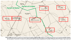
| Composite image created from detail from Ordnance Survey map, Six-inch Series, 2nd edition, Scotland, Aberdeenshire, Sheet XXXIX.NE, revised 1899, published 1901, with the location of East Broadmuir added from the 1st edition map. Image centred around DMS coordinates 57°23'26"N, 1°54'11"W. Reproduced with permission of the National Library of Scotland. |
There were a total of seven farms with the name "Broadmuir" split either side of the border between the parishes of Slains and Cruden in Aberdeenshire:
- Broadmuir (of Cruden)
- Broadmuir (of Slains)
- East Broadmuir
- Nether Broadmuir
- North Broadmuir
- South Broadmuir
- West Broadmuir
The farms have been identified in a range of maps and documents from the Ordnance Survey (OS), as follows:
- OS 6-inches-to-the-mile maps, first edition, Scotland, Aberdeenshire, sheet XXXIX (surveyed in 1867 and published in 1871);
- OS 6-inches-to-the-mile maps, second edition, Scotland, Aberdeenshire, sheet XXXIX.NE (revised 1899 and published in 1901);
- OS Name Book (1865-1871) Aberdeenshire, volume 22 (Parish of Cruden);
- OS Name Book (1865-1871) Aberdeenshire, volume 80 (Parish of Slains).
The table, below, provides the name of each farm, the parish in which it was located, and information about where their locations can be found on early and present-day maps:
| Farm name | Parish name | Description in OS Name Book | Appearance on OS 6-inch maps | Apparent condition (*) | Link to map coordinates |
|---|---|---|---|---|---|
| Broadmuir (Cruden) | Cruden | OS1/1/22/175 | 1st and 2nd edition maps | Extant | 57°23'37"N, 1°53'49"W |
| Nether Broadmuir | Cruden | OS1/1/22/176 | 1st and 2nd edition maps | Extant | 57°23'14"N, 1°53'44"W |
| North Broadmuir | Cruden | Not included | 2nd edition map only | Derelict | 57°23'37"N, 1°53'24"W |
| South Broadmuir | Cruden | Not included | 2nd edition map only | Extant | 57°23'24"N, 1°53'19"W |
| Broadmuir (Slains) | Slains | OS1/1/80/16 | 1st and 2nd edition maps | Extant | 57°23'27"N, 1°54'45"W |
| East Broadmuir | Slains | OS1/1/80/16 | 1st edition map only | Demolished | 57°23'24"N, 1°54'16"W |
| West Broadmuir | Slains | OS1/1/80/13 | 1st and 2nd edition maps | Demolished | 57°23'26"N, 1°55'07"W |
(*) The apparent condition of each location given in the table is based on a review of public domain satellite images in June 2020. The author would be pleased to hear from people with local knowledge about the farms of their history.
East Broadmuir only appears on the 1st edition map, so had presumably been abandoned (and possibly demolished) before the maps were revised for the 2nd edition in 1899.
In the OS Name Books, Nether Broadmuir was described as "three small farm houses, each having garden offices &c attached". On the 1st edition map the name "Nether Broadmuir" spreads across three separate groups of buildings. On the 2nd edition map, the same buildings are labelled separately as "North Broadmuir", "South Broadmuir" and "Nether Broadmuir"
- Login to edit this profile and add images.
- Private Messages: Send a private message to the Profile Manager. (Best when privacy is an issue.)
- Public Comments: Login to post. (Best for messages specifically directed to those editing this profile. Limit 20 per day.)