In this image:
When: 1730.
Uploaded: 7 Jul 2017 by M William Wykoff PH.D..
Comments: 2, WikiTree Popularity: 1.
Original digital image: 2249 x 1600 pixels. Adobe Photoshop CC 2015.5 (Macintosh) software. Dated 2017:05:22 12:42:41.
Do you love this photo? Maybe it's just interesting, or there's a story behind it? Please share it with the WikiTree community.

This image is open for viewing but you need to be logged in to edit the details. Please login here.
Comments: 2
There are no comments yet.
Login to post a comment.
M William Wykoff PH.D.
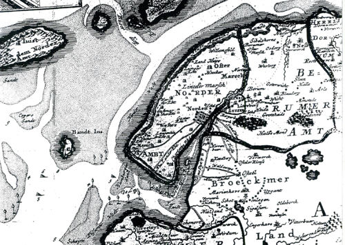
For those who may be wondering how an illiterate, orphaned young man named Pieter, son of Claes, found his way to Amsterdam from Marienhave in 1636, a later (1730) large-scale map depicting Ostfriesland shows clearly that nearby Norden was still a viable seaport for small ships (with a channel through shallow waters) connecting directly to the Leybucht (bay) to the North Sea. The small village of Marienhave and The Wykhof house-barn were landlocked by this time behind the progressive diking of the Leybucht. (See map in my booklet, p. 22). It was only a few miles, a short walk, from Marienhafe to the port town of Norden. Marienhave is shown on the map reproduced here in tiny letters just below the larger letters for the township Broeckmer Land (click on map above). When Pieter prepared to board the Rennselaerswyck in Amsterdam, it would have been known that he had originally sailed from Norden, and that was how he was identified on the passenger list. He was most assuredly born (ca.1616) and raised near Marienhave, not in Norden as it has sometimes been assumed. (The estimated birth year and age of Pieter Claessen is derived from the two facts that he left home in 1636, and other documented single male indentured immigrants, who were also receiving a mans wages, were in their 20s when they entered into the contract).
posted
by M William Wykoff PH.D.
M William Wykoff PH.D.
1730 (copywright free)
posted
by M William Wykoff PH.D.
