
Liberty County, Texas
- Profile
- Images
Location: [unknown]
Surnames/tags: liberty_county us_history texas
| ... ... ... is a part of Texas history. Join: Texas Project Discuss: Texas |

- Texas Space Page
- Leader- Mary Richardson
Contents |
History/Timeline

|
| Empresario colonies. |
- Liberty County was formed 1836 and organized 1837 by the Republic of Texas from Texas Colony. It was named for Spanish municipality, Libertad.[1]
The area which became the future Liberty County belonged to prehistoric Indians. Artifacts of the Orcoquisac villages have been found on the Jamison and Daniel sites. These are on the Trinity river, 3 miles N of Liberty where arrow points, pottery of the era around 1000 B.C. or earlier. The Indians tribe for this area were the Orcoquisac (Akokisa or Arkokisac) tribe. Obviously they traveled in this area by the river and thus were given a name associated with Indian tribes indigenous for the locale. (The Trinity River as we know it today was earlier known as Arkokisac River....[2]
- pre 1740 - Karankawa tribe were in this area until 1740s.
SEE Link: - Liberty County, Texas
- 1526 - It is reported the Spanish crown granted to Panful de Narvaez the right to colonize land between the Rio Grande and Florida. [3]
- 1748 - Spanish sent Joaquin de Orobio y Baster to explore. [3]
- 1756 - Spanish established Nuestra Señora de la Luz Mission and San Agustín de Ahumada Presidio for the Akokisa and Bidai Indians. [3]
- 1757 - Spanish maps show the Atascosito settlement with the a Spanish military road known as the Atascosito Road, which crossed the Trinity near the present site of Liberty. [3]1766 a storm destroyed parts of the mission
- 1770-1790 - a trading post called Arkokisa /Arkosisa was present near the town of Liberty,.[3]
- 1772 - the presidio was abandoned.
- 1807 - Coushatta Indians from Alabama inhabited the east side of the Trinity River .[3]
- 1810 - Settlers from Louisiana began arriving.
- 1818 Charles F. A. Lallemand and Antoine Rigaud tried to colonize at Champ d'Asile, near the site of present Liberty.[3]
- 1826-1831 - A new Atascosito District developed in Mexican Texas when settlers established an independent colony in 1826. Administration was at Atascosito until 1831.[3]
- 1826 -Grants were promised to American settlers such as the empresario grant in the area of Liberty and surrounding counties of Joseph B Vehlein. [3]
|
|
| Empresario colonies. |
- 1830 the Joseph Vehlein empresario grant became the Galveston Bay and Texas Land Company. Local administration of the area was conducted at Atascosito until 1831. [3] The Mexican government did not recognize the titles of settlers given by the Galveston Bay and Texas Land Company. The settlers and squatters of the coast area petitioned the commander- in chief of Coahuila and Texas colony for land titles and organization of a local government. [3]
- 1830- Liberty colony was considered to be part of the Atascocita District. Settlers of the district wanted to be part of Stephen F Austin's colony. This colony like all East Texas colonies had the same # of settlers who were slave holders. [2]
- 1831 - the land commissioner José Francisco Madero organized a municipality known as Villa de la Santísima Trinidad de la Libertad, (this was Southeast Texas) - the bounds on east were the Sabine River, and on the west - the San Jacinto River. On the north was Nacogdoches Municipality and Gulf of Mexico on the south. Hugh B Johnston was alcade. [3] José Francisco Madero granted thirty-six (36) land titles there, thus forming a new municipality, Villa de la Santísima Trinidad de la Libertad.
- Anglo Americans named this new seat of government “Liberty”, located 3 miles SW of Atascosito The new seat of government, called Liberty by the Anglo-Americans.[3]
- Dec 10 1831- Anahuac military commander, John Davis Bradburn tried to remove the office of ayuntamiento in Liberty on December 10, 1831, however the new colony survived. By 1836 the Republic of Texas granted a post office here.
- 1833-36 - Policies of settlers was "ignore" or "not hear" some of the government rules.... Since policy was not clearly enforced, many settlers went ahead and obtained additional slaves. Questions on why why Liberty county did not receive as much criticism on this matter. The settlers did have slaves, they just were not raising cotton. Liberty county settlers tended to raise sweet potatoes, corn, hogs, cattle which were all sold locally. There was less transportation needed. [4]

|
| Bridge - Trinity River. |
- 1835 - A consultation was held. 5 men represented Liberty area. Even without the land titles straightened out, the population was over 1,000 in 1835.
- 1835- Andrew Briscoe formed Liberty Volunteers, fought in the Battle of Concepcion and siege of Bexar in fall of 1835 [5]

|
- Feb, 1836 One of William B Travis's letters requesting aid at the Alamo was delivered to a plantation by Joseph Dunman.[5]
- March 6, 1836 - 3 of Liberty county's settlers were killed in the Battle of the Alamo Edward Taylor, James Taylor, and George Taylor.
- April, 1836 - 50 of this area's colonists participated in the San Jacinto Battle.[5] Mexican prisoners captured at San Jacinto were sent to Liberty before release.
- 1830's- 1850's -Liberty was a shipping point for plantations along the Trinity, to ship lumber, and for other shipments from farmers.
- 1836 Republic of Texas granted Liberty a post office.
- 1830-1850's - General Sam Houston practiced law in this area. General Sam Houston maintained two plantation homes in Liberty County until his death.
- 1836 - When Liberty County formed and organized in 1836 in the new Republic of Texas, the area included all of the future Tyler County and parts of what later became Hardin, Chambers, San Jacinto, and Polk counties. Liberty was named county seat and incorporated in 1837. Sam Houston maintained two homes in the area and purchased more than 20,000 acres of land within the county's original boundaries.[3]
- 1838 2nd year of the Republic of Texas. This was first year of complete and undamaged Liberty county tax records. 166 heads of house hold paid their property taxes. The ledgers ledgers only asked for limited information, but land, horses, cattle and slaves were listed.[5]
- 1838 -a school was founded in Liberty, the county seat of Liberty,
- 1850 - Some wealthy aristocratic Creole planters from Louisiana also settled in Liberty so that by 1850 the population was up to 2,522.
- 1860 Liberty County residents voted for secession (422 to 10 )
- 1861-1865 - Liberty Invincibles were organized in 1861 for duty in Civil War.[5]
- Slavery Slavery movement
- Reconstruction. Residents cooperated with the Freedmen's Bureau and did not want their county re-organized. [5]
- 1866-67 Smallpox and yellow fever epidemic
- 1875 -Liberty County records destroyed by fire in 1875 and damaged by a storm in 1900
- 1900 the town had roughly seventy houses
- World War II, a camp for German prisoners of war was established at the Liberty fairgrounds. [5]

|
Government Offices
- The Mexican government passed the ban on slaveholding in the early 1830's.
- Anglo Americans named this new seat of government “Liberty”, located 3 miles SW of Old Atascosito. The new seat of government, called Liberty by the Anglo-American.[3]
- - Liberty town is the 3rd oldest town of Texas
- LIBERTY (9,245) county seat; petroleum-related industry, agribusiness; library, museum, regional historical resource depository
- Liberty Bell,
- Price Daniel House; hospital; Jubilee in March.
Liberty county has had 7 courthouses.
- Town of Liberty was the county seat back when Liberty was a municipality /colony/territory. It was one of 23 Territories established by Mexico in the 1830s. Municipalities became counties in 1836 when Texas won independence from Mexico; Liberty became county seat of Liberty County.
- Courthouse was erected here in 1831 and was made of hewn logs. [6]
- Courthouse #2- was one-story frame house of split cypress boards was constructed in 1840. [6]
- Courthouse #3 Constructed in mid 1840's - 2-story building was built on the Square. Measurements were 32 ft X 40 ft. The first floor was a courtroom. [6]
- Courthoue 4 - was built 1857 - was brick, and the town of Liberty financed this by selling land owned by the town of Liberty. Fire destroyed this one 1872.[6]
- Courthouse 5 was also brick, was built in 1877. This building deteriorated and was condemned after 18 years and removed from the Square. [6]
- Courthouse 6 - the Masonic Lodge laid the cornerstone for this #6 courthouse 1895. This was 3-story and became a gathering place that was popular.[6]
- Courthouse 7 built of Texas Cordova cream limestone was completed in 1931.[6]

|
| 1896 Courthouse #6. |
- Liberty County records were destroyed by fire in 1875 and damaged by a storm in 1900

|
| 1931 Liberty Co., TX courthouse. |
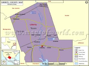
Geography
- SE Texas
Liberty County is 1,176 square miles of land located east of the bordering Harris County (which contains the the City of Houston)
- Trinity River flows through this county, dividing the county in half beginning with northern part, then the San Jacinto River forms.
Liberty county, Texas had lowest temperature on record in winter - December 24, 1989, was 7°F. Summer temperature high was July 20, 1913, - 108°.The Gulf of Mexico moderates the temperatures to be mild winters. Below freezing temps may average 19, but these seem to only be a few hours. Abundant rainfall occurs due to the Gulf, so the annual precipitation totals of 30-60 inches and are occurring 75% of the time. Snow rarely occurs, such as Dec 22, 1989 - 1.7 inches when the low was 7°. [7]
Adjacent counties
When Liberty county was formally recognized as a county, it was large, composed of Tyler County and parts of what later became Hardin, Chambers, San Jacinto, and Polk counties.
- Polk County (north)
- Hardin County (east)
- Jefferson County (southeast)
- Chambers County (south)
- Harris County (southwest)
- Montgomery County (west)
- San Jacinto County (northwest)
Formed From
Tyler County
Protected areas
- Big Thicket
- national wildlife refuge; ;
- Trinity Valley exposition;
- Liberty Opry.
- historic sites
Demographics
- The racial makeup of the county was 78.90% White, 12.82% Black or African American, 0.47% Native American, 0.32% Asian, 0.03% Pacific Islander, 6.03% from other races, and 1.43% from two or more races. 10.92% of the population were Hispanic or Latino of any race. - A different perspective of racial breakdown shows White alone (68.5%), Hispanic or Latino (of any race) (18.70%), Black or African American alone (10.9%0
Schools
- Dayton ISD (portions of the district extends into another county)
- Liberty ISD
- Cleveland ISD (portions of the district extends into other counties)
- Tarkington ISD
- Hardin ISD
- Hull-Daisetta ISD
- Devers ISD
Cities
- Ames
- Cleveland
- Daisetta
- Dayton
- Dayton Lakes
- Devers
- Hardin
- Liberty (county seat)
- Mont Belvieu (partly in Chambers County)
- North Cleveland
- Plum Grove
Town
- Kenefick
- Davis Hill
- Dolen
- Eastgate
- Hightower
- Macedonia
- Moss Bluff
- Moss Hill
- Rayburn
- Raywood
- Romayor
- Rye
- Tarkington Prairie
Demographics
- Liberty Municipal Airport is located east of Liberty.
- Cleveland Municipal Airport is located east of Cleveland.
- Population density was 60 people per square mile (23/km²). There were 79% whites.
- By the year 2000 there were 8,033 residents and 526 businesses in Liberty county, Texas.
Resources
- Oil, gas.
- Agriculture: Beef cattle;
- Rice is principal crop.
- nursery crops, corn, hay, sorghum, bees (first in number of colonies). Market value $34.9 million. *Some lumbering.
- Sam Houston Regional Library and Research Center
Corrections
- Texas Department of Criminal Justice - women's prison and two women's state jails, all co-located with one another, in an unincorporated area.
- L.V. Hightower Unit prison
- Dempsie Henley Unit
- Lucille G. Plane Unit jails are 4 miles (6.4 km) north of Dayton
- Cleveland Unit, a prison for men privately operated by the GEO Group, Inc. on behalf of the TDCJ,
Census
- 1850 -- 2,522
- 1860 -- 3,189
- 1870 -- 4,414
- 1880 -- 4,999
- 1890 -- 4,230
- 1900 -- 8,102
- 1910 -- 10,686
- 1920 -- 14,637
- 1930 -- 19,868
- 1940 -- 24,541
- 1950 -- 26,729
- 1960 -- 31,595
- 1970 -- 33,014
- 1980 -- 47,088
- 1990 -- 52,726
- 2000 -- 70,154
- 2010 -- 75,643
Est. 2015 -- 79,654
Notables
- General Sam HOUSTON -maintained 2 plantations here. land commissioner José Francisco Madero established an office in the settlement and on May 5, 1831, granted thirty-six land titles there, thus forming a new municipality, Villa de la Santísima Trinidad de la Libertad.
- David G. Burnet, Empresario, practiced law here
- Hugh B. Johnston was made alcalde.
- Marion Price Daniel, Sr. -38th Governor of Texas, US Senator
- Bill Daniel, Governor of Guam, Texas Congressman
- Bill Dodd, Louisiana politician
Land Grants
- May 5, 1831 Land commissioner, José Francisco Madero granted 36 land titles there, thus forming a new municipality, Villa de la Santísima Trinidad de la Libertad.
- Hugh B. Johnston was made alcalde.
- Deed Records date back to 1875; Marriage Records, 1875;
Cemeteries

|
- Cleveland Memorial Cemetery
- Oak Dale Cemetery
- Linney Cemetery
- Magnolia Park Cemetery
- Abshier Cemetery, Devers
- Abshier Cemetery
- Moss Hill Cemetery
- Daniel Family Cemetery
- Liberty Catholic Cemetery
- Liberty Cemetery
- Find a Grave cemeteries #1
- Find a Grave cemeteries#2
- Cemeteries of Liberty county, Gloria Mayfield
- Find a Grave- Liberty, more
- Liberty county, Texas Genealogy TxGen
- Liberty cemeteries- Rootsweb
- cemeteries, Liberty county, Texas
Sources
- ↑ https://texasalmanac.com/index.php?q=topics/government/liberty-county
- ↑ 2.0 2.1 https://en.wikipedia.org/wiki/Liberty,_Texas
- ↑ 3.00 3.01 3.02 3.03 3.04 3.05 3.06 3.07 3.08 3.09 3.10 3.11 3.12 3.13 3.14 https://www.tshaonline.org/handbook/online/articles/hcl08
- ↑ http://scholarworks.sfasu.edu/cgi/viewcontent.cgi?article=2626&context=ethj
- ↑ 5.0 5.1 5.2 5.3 5.4 5.5 5.6 Handbook of Texas Online, Diana J. Kleiner, "Liberty, TX (Liberty County)," accessed June 17, 2016, http://www.tshaonline.org/handbook/online/articles/hfl04. Uploaded on June 15, 2010. Published by the Texas State Historical Association
- ↑ 6.0 6.1 6.2 6.3 6.4 6.5 6.6 http://www.texasescapes.com/TexasGulfCoastTowns/Liberty-County-Courthouse-Liberty-Texas.htm
- ↑ Oaktrust Liberty County History
- https://en.wikipedia.org/wiki/Liberty_County,_Texas
- http://texasalmanac.com/topics/government/liberty-county
- Encyclopedia of the Alamo and the Texas Revolution, By Thom Hatch
- Handbook of Texas Online, Diana J. Kleiner, "Liberty, TX (Liberty County)," accessed June 17, 2016, http://www.tshaonline.org/handbook/online/articles/hfl04. Uploaded on June 15, 2010. Published by the Texas State Historical Association.
- Liberty county, Texas
- Liberty county Genealogy and History
- Find a Grave cemeteries #1
- Find a Grave cemeteries#2
- Cemeteries of Liberty county, Gloria Mayfield
- Find a Grave- Liberty, more
- Liberty county, Texas Genealogy TxGen
- Liberty cemeteries- Rootsweb
- cemeteries, Liberty county, Texas


- Login to edit this profile and add images.
- Private Messages: Contact the Profile Managers privately: Mary Richardson and Paula J. (Best when privacy is an issue.)
- Public Comments: Login to post. (Best for messages specifically directed to those editing this profile. Limit 20 per day.)