
George
Vicars
Born in Auckland St Helen, Durham, England
Son of Henry Viccars
and [mother unknown]
[sibling(s) unknown]
Husband of
Ellen (Dobyson) Vicars
— married
1 Aug 1627 in Hamsterley, Durham, England
Descendants Died about
at about age 76
in Auckland, Durham, England
Profile last modified
| Created 17 Dec 2020
This page has been accessed 247 times.
Biography
George was born in 1603 to Henry Vickars. [1]
In August 1627 at Hamsterley he married Helinor Dobbison (1606-1671). [2]
George and Elinor had a number of children including Thomas, George, and William around 1640.
George accepted the Durham Protestations of 1641 at Hamsterley.
In January 1658 he took up a copyhold lease on two acres of waste land near Gaunless Bridge owned by the Lord Bishop. (The lease was written in English). On the 24th day of January in the year of our Lord one thousand Six hundred ffifty Eight came George Vickers ? out the Court at Ramshaw before Antony Pearson, Deputy(?) Steward, And took of the Lord two acres of land late of the Lord’s waste Lying at Gawnleeze Bridge, Abutting Upon a Tenement at Ramshaw Sometimes Robert Wild on the North, And the Water race of the Mill Called Evenwood Mill on the South, In which Richard Thompson And Margarett his wife therein having right, She the said Margaret being Examined Alone Not compelled By force or through Fear of her Said husband But of her owne voluntary and ffree will (surrender) their whole Right Estate Title Claim and Demand have Surrendered and quit claimed into the hands of the lord to the use And Behoof of the said George Vickers to have to the said George Vickers and his Sequells in right according to the Custome of the Court Rendering therefore By year and At usual termes as first Was wont to be remembered and giving(?) to the Lord and the neighbours the dutyes and Services And Customs by pledges And thereupon this he (George) was thenceforth admitted tenant.
In 1662 he renewed the lease and added 30 acres of land at Ramshaw (plus a furnished house). Included in the lease were his three sons: Let it be noted that on the twentieth day of February in the fourteenth year of the reign of Charles the Second, by the grace of God King of England etc., came George Vickers, Elinor his wife, Thomas Vickers, George Vickers and William Vickers, sons of the aforesaid George and Elinor, outside the court in the city of Durham, before John Heap, esquire, steward; and they took from the lord one messuage and thirty acres of land with appurtenances in Ramshaw, and also two acres of land lying at Gaunless Bridge, abutting onto the tenement of Robert Wild at Ramshaw on the north side and the source of the water-mill called Evenwood on the south side, in which Robert Aisley then held all the right, estate, title, claim, interest and demand, and he surrendered and quitclaimed it into the hands of the lord for the use and benefit of the aforesaid George, Elinor, Thomas, George and William; to hold to the same George and Elinor his wife for and during the natural lives of the same George and Elinor, and whichever of them lives longer, and after their deaths to the aforesaid Thomas, George and William Vickers and their descendants by right, according to the custom of the court, paying thenceforth at the usual terms of the year the annual rent that was previously accustomed to be paid; and they made a pledge to the lord and the occupying neighbours etc.
The 30 acres of land plus furnished house in Ramshaw were surrendered and transferred to Robert Aisley in 1663.
Between 1660 and 1664 Court Barons set a penalty (lay a paine) of 3 shillings 4 pence for each of the following offences such as not repairing: 'the West Poole at Ganles Bridge'; 'the steepe fould'; 'the Pin fould wall' (before the 17th day of November); 'the gate well'; and 'the Water sewer that goeth through Thomas Hoggart's Garth'.
A fold/fould is a pen or enclosure (usually for animals). Pin fould would refer to the village pound. One meaning of the old English 'steep' with respect to water is 'having a headlong course, flowing precipitously.' Hence 'steepe-fould' may relate to the water-mill. In that case it may refer to an enclosure around the intake (or the race). The 1888 OS map shows a weir at that point. The west pool may have been on the upstream side of the bridge, important in protection from undermining. These entries suggest that George Viccars performed general contracting work including stone masonry, construction in timber, and thatch.
From the Health Tax records to Lady Day (25 March) 1666 George had 2 hearths or fireplaces at Evenwood Barony (as distinct from Evenwood Town). Rather than the usual single hearth, it indicates he had a more substantial house, and hence was relatively well off.
George was paying £1-7-4 annual rent for his holdings in 1670. In 1674 he surrendered a lease in Lynsack which transferred to Henry Vicar (1616-). [3]
He served on the Evenwood Court Baron for many years, his last being May 1679. At that time he would have been over 75 years old. His son Thomas also served regularly from 1671.
In January 1691 the land by Gaunless bridge was surrendered by Thomas and George Viccars, and William Viccars deceased. This was passed on to Christopher Sidgwick. [4]
Elioner Vickers passed away in 1671 in the Auckland district. [5].
Research Notes
1/The original leases of Halmote Court records written in Latin were obtained from the Durham University Archives. My heartfelt appreciation goes to 'Bookbox' from Rootschat for the translations.
2/ Evenwood Water Corn Mill. Although the first record of a mill in the north-east is in the 3rd century AD, it was not until the 12th century that there is definite proof of a water corn mill in the Wear basin. The church of Auckland St Helen dates from this time. The parish of the same name was roughly an oval 6 by 4 miles, with its long axis running NW to SE. (It is smaller nowadays). A stream bisects the rather flat countryside. Although it creates beautiful valleys and countryside, it rises in Cockfield Fell as a mean trickle and doesn't wax to a massive flow. On its gradual journey it meanders widely - east then north to join the River Wear below Bishop Auckland. The 9th century Vikings found it inadequate for supporting fish, powering mills, and lacking much in the way of floodplains which would double as rich fertile meadows. Hence, they gave it the unflattering name 'gaghenles', meaning 'useless', which became anglicised as Gaunless.
Despite these early settlers not finding a use for the stream, a corn mill and a fulling mill for treating cloth had been established at Evenwood by the time of Bishop Hatfield's survey of 1380. Taken after the outbreak of the Black Death of 1349-50 it suggests the mills had been established some time earlier. The presence of the fulling mill suggests wool from sheep reared in the Pennine moors was brought to the manor. The water mill was rented to Willelmus Granup for 11s 8p per year, and the fulling mill to Johannes Walker for 3s 4p. Halmote Court records from 1413 to 1506 indicate rents for the water corn mill let to an individual or named group for a period of years. When it was out of use the water mill was subject to lengthy repairs.
Corn/corne included any grain such as barley, oats, rye, and wheat, but probably not rice, nor the so-called Indian corn that only became commercially available towards the end of the 19th century in Britain. Sometimes pulses like beans and peas may also have been included. Probably oats much more than wheat were grown in Durham in the 14th century. That changed over time. The grain itself was consumed, not sold, about 2/3 being used for brewing, while the remaining 1/3 was baked into bread.
The corn mill was an important part of the farming community in England from 1300 to the 1900’s and the miller was a skilled trade. The miller did not just serve the farmer but also the farm labourers who received all or part of their wages in the form of corn. The skill of the miller was crucial in being able to create value from the crops. The grain arrived in sacks at ground level and then were lifted by hoist to the top floor. The top of the mill is where the miller stood. He controlled the sluice gate to vary the amount of water pushing the wheel around; the gap between the millstones; and the flow of grain to the stone. This is a difficult skill and the grinding had to be carefully controlled to maximise and polish the grain, with flour yield depending on the grain quality, moisture content and the condition of the millstones. The flour meal dropped down a chute and bagged with the family of the miller working as labourers. Millers often had large families with seven or eight children being common. [6]
When Chaucer wrote Canterbury Tales in 1386 he introduced the medieval miller, a significant person in medieval life, though often reviled. Medieval people were very religious, fasting and feasting often being involved in festivals and pilgrimages. Bread was the one food not restricted during fasting. In those times the type of bread you ate defined your social status. Bread was eaten at every meal, and to fill you up if there was nothing else to eat. William Harrison in "The Description of England" in 1577 explained, The gentilitie commonlie provide themselves sufficientlie of wheat for their owne tables, whilst their housefhold and poore neighbours are inforced to content themselves with rie, yea, and in time of dearth, manie with bread made of beans, peason or otes, or altogether... Last of all the summer duties was the repairing of the mill, which formed a necessary feature of every estate, and was generally farmed out by the lord, the miller taking his toll of the tenants, upon whom it was compulsory to bring their grain there to be ground. It was also a time for the setting up of folds and pens and foi the making of weirs.
Multure ('Mooter' in local parlance) was the toll or fee in kind for grinding corn. In a traditional rural society, a miller was often wealthier than ordinary peasants, which could lead to jealousy.
By 1647 there were five mills in the manor of Evenwood. The fulling mill was not mentioned in the survey but the corn mill, worth £13 per annum, was still in operation on the Gaunless.
The site of the water corn mill from the mid 17th century is well known, being 740 yards downstream of the Evenwood bridge. Being an excellent site there is no reason to suppose it is not the same as the one recorded in the 14th century. As seen below, it certainly was on that site for many years prior to 1673. Some suggest the early fulling mill may also have been at that location.
The 1658 Halmote Court record above indicates George Viccars' land was on the north bank of the river near (the east side of) the bridge. It was a new lease taken from 'the Lord's waste', ie land previously not tenanted. It was the same side as the hills of Raley Fell rising steeply from Ramshaw. To the south on the other side of the river was the mill race. It extended under the bridge to an intake structure about 140 yards upstream. There was a footpath from Evenwood village leading south to the mill. Access for inwards and outwards goods was much easier over the relatively flat ground via Viccar’s land.
A dispute about access to the mill appears to have occured. Before the court in October 1670 John Hodshon aged sixty years or thereabouts in full Court being sworne Saith he hath known a high way for bringing of Milstones through ye grounds of George Viccars to ye Lows Mill called Eavenwood Mill. Tho(mas) Hopper likewise sworn said ye like(wise).
Court records of April 1673 give further information: The further p(re)sentment of the Grand Enquest of the Court at Eavenwood. Wee p(re)sent and say that wee have heard the Testimony of severall neighbours and others who have knowne and have had the Mill called Eavenwood Mill in their possession who all averr that the way to the said Mill aswell for horse as alsoe for Milstones was leading from the fell and through the grounds of George Viccars w(hi)ch he hath now in possession without any interrupc(i)on or hinderance at all and likewise that the owners and farmers of the said Mill did keepe Pullan* and sometimes Swine at the Said Mill and did lead & carry away the Manure from it and this some of the Jury cann likewise testifye and likewise the Thatch and Timber for the s(ai)d Mill was carryed the same way without interrupc(i)on untill of late by the said George Viccars. *(pullan = poultry)
The Ordinance Survey maps of 1857 and 1888 indicate a ford just below the mill, and this was the probable entry and exit point for people, horses, millstones, timber, thatch, manure, and the ground grain.
This mill itself was built upon a level terrace four feet above the present level of the Gaunless River, and cut into the hill so that a bank some twelve feet is formed. A 900 yard leet conducted water from the Gaunless along the crest of this bank to feed a high breast overshot wheel at least 16 feet in diameter, which was enclosed adjacent to the mill. This drove three sets of stones.[7]
The early buildings would have been constructed of local stone and covered in thatch. The leet stretched upstream and under the road bridge to the intake structure.
In corn mills rotation about a vertical axis was required to drive its stones. The horizontal rotation was converted into the vertical rotation by means of gearing, which also enabled the runner stones to turn faster than the waterwheel. The number of runner stones that could be turned depended directly upon the supply of water available. Adjusting the sluice gate and thus the flow of the water past the main wheel allowed the miller to compensate for seasonal variations in the water supply. Finer speed adjustment was made during the milling process by tentering, that is, adjusting the gap between the stones according to the water flow, the type of grain being milled, and the grade of flour required.
The overshot wheel was a later innovation in waterwheels and was around two and a half times more efficient than the undershot. On these the water flow is brought to the top of the wheel. The water fills buckets built into the wheel. As the buckets fill, the weight of the water starts to turn the wheel. The water spills out of the bucket on the down side into a spillway leading back to river. Since the wheel itself is set above the spillway, the water never impedes the speed of the wheel. The impulse of the water on the wheel is also harnessed in addition to the weight of the water once in the buckets. Overshot wheels require the construction of a dam on the river above the mill and a more elaborate millpond, sluice gate, mill race and spillway or tailrace.
The mill dam, of course, was vital to the whole operation, it being necessary to regulate the amount of water passing onto the wheel, and as a certain amount of information is available on the large dams that were set on the Wear itself, it would be appropriate to note the construction of this important factor. The mediaeval dam was essentially a heap of wood, stones and moss arranged in varying degrees of sophistication according to the temper of the times and the care of the miller. Two methods were used, often in conjunction, but occasionally separately. Sometimes the base of the dam was composed of a trapezoidal pile of stones upon which were placed branches to form the ‘ryssdam’... At other times the base of the dam was formed by hurdles weighted down with stones upon which was then placed the ryssdam of branches, the whole being made waterproof by the application of moss to the interstices. Where the dam joined the river bank at the mill, strengthening was needed, and a masonry wall was usually constructed… Each year the dams had to be repaired with the application of moss… At other times hurdles had to be laid down… It was not until the eighteenth century that masonry dams became the norm… [8]
Halmote court records 1711-14 show William Stephenson (1670-) paying an annual rent for the Evenwood Mill of £1-6-8. In 1725 sixty year old Gertrude Langstaffe deposed at a trial that for 30 years she and her sister, “followed the business or employment of common millers for public sale and grinded (sic) all their oats which they made into oatmeal sometimes at West Auckland Corn Mill, and at other times at Evenwood Mill.”
The mid 1700’s was a great period of prosperity for corn farming in England with new strains of wheat and oats producing an enormous increase in productivity. The number of corn mills expanded and the demand for the skills of the miller followed. The Corn Laws (protectionism for home-grown corn) were repealed in 1846 and this meant that mills became centred on coastal sites to take advantage of cheaper imported wheat. The rural mills were less economic and closed. Flour milling was further transformed in the 1880’s with the introduction of steam-powered roller mills.[9]
Evenwood Mill eventually passed into private hands with John Buck of West Auckland owning it around 1763. In 1765 an inclosure for an accessway was granted to access the mill via George Hodgson's allotment on the north side of the river at Railey Fell. It began at the turnpike road lead through various gates and across the Gaunless to the mill. Passage was granted on foot or by horses (laden and unladen), cattle and carriages. [10]
By 1789 the mill was the property of John Palmerly (1758-) who appears to have worked it then leased it to Charles Bowser (1760-) then Ralph Vart (1772-1850). Ralph's son John took over the lease when John Palmerly died in 1821, and the mill passed to his son William Palmerly. Having no sons William appears to have sold it John Vart (1800-) around 1832.
The decline in water corn milling after its zenith in 1820 was rapid. A pattern that had taken 700 years to establish was almost entirely removed in the following century. [11] Coal was mined intensively in Auckland District including nearby the mill site at Evenwood. Steam powered mills quickly replaced water driven ones. Evenwood mill was spared that fate for some time. From at least 1827 until the mill’s abandonment in 1904 the mill was operated by the Vart family, who have a long record of milling in the Auckland District.
The attached OS map surveyed in 1856 shows the mill and race but no detail of the intake other than its approximate position upstream of the bridge. A footpath runs north from the direction of Evenwood to the mill. A footbridge crosses the Gaunless at the site below a ford. The OS 1888 map provides slightly different building footprints including the mill house, and a weir at the intake.
The accompanying sketch shows the mill around 1900 viewed from the north across the Gaunless River. Water from the millrace flowed from the right (west), entered the main (central) building from the uphill side behind, and turned the enclosed millwheel. The mill house is shown adjoining the right hand side of the main building. Other ancilliary buildings, perhaps for grain and flour storage etc, are shown on the left. In the foreground is a small bridge across the river and accessways leading from the fell.[12]
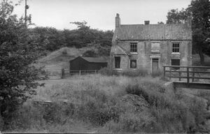
The mill closed in 1904, ending over 500 years of milling on the Gaunless River at Evenwood. The mill buildings were demolished as unsafe in 1956. Little remained as shown in the accompanying photo viewed from the north. The mill house house was demolished in 1990, rebuilt at 90 degrees to its original aspect, and extended.
The following deeds and counterpart leases are available from Durham University Archives: [13] CCB/D/1956/390/185285 1661 to 1799 - 8 Old Deeds.
CCB/D/1956/105/54853 29 October 1763 John Buck. Evenwood mill.
CCB/D/1956/105/54854 29 January 1799 John Palmerley. Evenwood mill.
CCB/D/1956/105/54855 26 March 1832 John Vart. Evenwood mill.
CCB/D/1956/105/54856 10 June 1834 John Vart. Evenwood mill.
The following Land Tax Returns in Evenwood and Barony Township may also relate to the Mill:[14]
1759 & 1760 Property of [not given] occupied by [not given] Evenwood Mill
1789 Property of John PALMERLEY occupied by John PALMERLEY
1803 Property of John PALMERLEY occupied by Charles BOWSER
1812 Property of John PALMERLEY occupied by Ralph VAIT
1817 Property of John PALMERLEY occupied by Ralph VART
1824 Property of William PALMERLY occupied by John VART
1827-30 Property of William PALMERLEY occupied by John VART. Mill and land.
Sources
- ↑ Auckland St Helen : St Helen : : "Parish Register" database, FreeREG (https://www.freereg.org.uk/search_records/58180484e93790ec8b9516e9 : viewed 27 Dec 2020) baptism George Vickars 20 Nov 1603
- ↑ "England Marriages, 1538–1973 ", database, FamilySearch (https://familysearch.org/ark:/61903/1:1:NLZK-GNB : 13 March 2020), George Vickars, 1627.
- ↑ https://www.familysearch.org/ark:/61903/3:1:3Q9M-CS2G-6S16-S?i=69&cat=1018322
- ↑ https://www.familysearch.org/ark:/61903/3:1:3Q9M-CS1G-L1YR?i=644&cat=1018322
- ↑ https://www.durhamrecordsonline.com/
- ↑ https://www.coxonclub.com/corn-mill-millers-northumberland-england
- ↑ Kirby, D. A. (1968) Some physical and economic aspects of water use in the wear basin. Doctoral thesis, Durham University. http://etheses.dur.ac.uk/9371/
- ↑ Kirby, D. A. (1968) Some physical and economic aspects of water use in the wear basin. Doctoral thesis, Durham University. http://etheses.dur.ac.uk/9371/
- ↑ https://www.coxonclub.com/corn-mill-millers-northumberland-england
- ↑ https://iiif.durham.ac.uk/index.html?manifest=t2mbn999679p&canvas=t2t9593tx776
- ↑ Kirby, D. A. (1968) Some physical and economic aspects of water use in the wear basin. Doctoral thesis, Durham University. http://etheses.dur.ac.uk/9371/
- ↑ The original photo can be obtained from Durham County Record Office http://www.durhamrecordoffice.org.uk/article/11111?SearchType=Param&CatRef=D%2fPh+333&ImagesOnly=Y&ImageView=List&Display=50&Page=2&ItemID=170089&ImageID=542085
- ↑ http://reed.dur.ac.uk/xtf/view?docId=ark/32150_s15425k969v.xml
- ↑ http://www.durhamrecordoffice.org.uk/article/11111?SearchType=Param&Variations=N&Keywords=q%2Fd%2Fl+detail&ImagesOnly=N&ItemID=910848
Is George your ancestor? Please don't go away!
 Login to collaborate or comment, or
ask our community of genealogists a question.
Sponsored Search by Ancestry.com
DNA
No known carriers of George's DNA have taken a DNA test.
No known carriers of George's DNA have taken a DNA test.
Have you taken a DNA test? If so, login to add it. If not, see our friends at Ancestry DNA.
Images: 7


Comments
Leave a message for others who see this profile.
There are no comments yet.
Login to post a comment.
Featured National Park champion connections: George is 28 degrees from Theodore Roosevelt, 28 degrees from Stephanus Johannes Paulus Kruger, 30 degrees from George Catlin, 31 degrees from Marjory Douglas, 37 degrees from Sueko Embrey, 29 degrees from George Grinnell, 34 degrees from Anton Kröller, 29 degrees from Stephen Mather, 26 degrees from Kara McKean, 33 degrees from John Muir, 24 degrees from Victoria Hanover and 41 degrees from Charles Young on our single family tree. Login to find your connection.