
Montague County, Texas
- Profile
- Images
Location: [unknown]
Surnames/tags: montague_county us_history texas
| ... ... ... is a part of Texas history. Join: Texas Project Discuss: Texas |

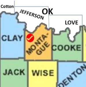
| Northwest |
North Jefferson County, Oklahoma |
Northeast Love County, Oklahoma |
||
| West Clay County |
Montague County, Texas | East Cooke County |
||
| Southwest Jack County |
South Wise County |
Southeast |
||
Contents |
History/Timeline
- Montague County was formed 1857 from Cooke County and organized in 1858. [1]
Montague county, Texas is named in honor of Daniel Montague, who lived over in Cooke County. Daniel was a surveyor of Fannin Land District and served in the Mexican American War. [2]
Comanche, Wichita, and Kiowa Indians inhabited the western Cross Timbers before French trappers or Spanish explorers. [3]
- 1747 - agreement between French trappers and Wichita-Comanche alliance. [3]
- 1757 - 2 settlements on the Red River banks (N boundary) of Montague county. [3]
- Larger village - north or river inhabited by Taovayas (branch of Wichita Indians)[3]
- Smaller village - south of river inhabited by Wichitas Indians
- 1759 -The Spanish raided on both villages, Both had a moat and stockade and the Spanish lost the battle.[3]
- 1779 - Athanase de Mézières established peace, renamed the 2 villages San Bernardo, San Teodoro.[3]
- 1812 - Smallpox caused Indians to abandon their settlements. (European diseases caused deaths to the American Indians due to the people had no resistance to these new diseases.)[3]
- Anglo Americans found the villages, renaming Spanish Fort.[3]
- 1857. Texas state government formed Montague County. 1858- it was organized [3]
- 3 villages were in the Montague county. None present in the geographic center.
- Montague, Texas was established as county seat in an uninhabited area. (Montague county only had 1000 settlers who were from Tennessee, Kentucky, and Arkansas , Illinois, Indiana, Ohio) arrived. This county did not have the plantation based slaveholding society [3]
- 1861 -The lack of a plantation-slaveholding-society and thus not having as many slaves, led the Montague County to reject secession (86 to 50). Its 849 residents, with 34 slaves, were more concerned with preserving their lives than the union!!! If Texas joined the Confederacy, federal troops would withdraw from the Red River area. Montague settlers did not want the Union - Federal soldiers to leave. (They gave protection against Indian raids.) [3]
- 1863 - An Indian attack destroyed the small Illinois Bend community.[3]
- 1860's to mid 1870's - bands of Comanche and Wichita Indians continued raids on settlers in the county.[3]
- 1870 - there were 890 residents.[3]
- 1878 - Governor pronounced Montague no longer a frontier county. [3]
- 1880s the population was 11,000. The abundance of grasslands had attracted cattlemen.[3]
- 1880- 1905 -residents concentrated on cattle raising. Farms grew forage for livestock and food.[3]
- 1882 - railroads -Fort Worth and Denver Railway reached SW Montague County. This enabled the growth of Bowie, Sunset, and Fruitland. [3]
- 1887 -Gainesville, Henrietta and Western Railway went through N-central Montague County with 3 more towns (Saint Jo, Bonita, and Belcherville). Then the Rock Island Railroad[3]
- Montague, Texas, the county seat, was not touched by the tracks of the three rail systems was the county seat. [3]
- 1884 - election voted for Bowie to be county seat, but it was not a 2/3 majority. Montague has never exceeded 500 people. Without the railroads, the other towns outgrew Montague.[3]
- 1890's -cattle herds as the focus for farmers/ranchers were replaced by cotton fields.#acres devoted to cotton increased from just under 11,000 in 1880 to well over 78,000 in 1900. [3]
- 1900 - there were 78,000 acres of cotton and 35,798 bales of cotton. [3]
- 1910 -boll weevil arrived[3]
- 1914 -peak year for cotton production (forty gins processed 43,595 bales of cotton)
- 1927 -1930's the county produced over four million barrels. The county averages to 2 million barrels/year. [3]
- 1940- 1980 the Nocona Boot Company, established at Nocona in 1887 by Herman J. Justin continues to be a major confirming company.. [3]
- 1960s farmers turned to truck farming, planting watermelons, tomatoes, and potatoes. [3]
- 1961 Montague County returned to cattle ranching and led the state in the number of registered Angus; in 1980 the county reported 65,000 cattle.[3]
- 1980 - Farmers also led the state in the production of apples and were sixth for peaches.
- 1980 - Johnson ranch at Bowie covered 350 acres and housed a 250,000 egg incubator. The ranch shipped White Leghorn chickens throughout the United States and Canada.[3]
- Sept 26 , 2009 - September 26, 2009, an historical marker on the Chisholm Trail was established near Red River Station in Montague County. The 5.5-foot concrete marker is the last of 12 established in Montague County as part of a joint project of the Texas Lakes Trail and the Montague County Historical Commission to outline the Chisholm Trail.[2]
- 2009- Texas governor, Rick Perry declared a state of disaster for Montague County due to many fires in a large portion of the county.When interviewed, Governor Perry called the fire "the most vicious" he'd ever seen.[2]
- 2010 Montague county population was 19,719. [2]
- Beef, hay, wheat, dairy products, pecans, peaches, and melons were the chief agricultural products.
Government Offices
Montague County, Texas is named in honor of Daniel Montague , who lived over in Cooke County. Daniel was a surveyor of Fannin Land District and served in the Mexican American War. [2][3]
Montague, Texas remains the county seat even though its population is small.
Montague county has had 4 courthouses ( 1858, 1879, 1885 and 1912 )[4]
- 1858 - 1st Courthouse - was meant to be a temporary building, but was still present after the civil War. It was a log cabin. The court used an old frame store on north side of square while the new wood frame 2 story building was built. It burned Feb 25, 1873 and all county records were lost.— Terry Jeanson[5]
- 1879 2nd courthouse was sandstone, tin roof, with a dome. This building burned Mar 31, 1884. It was felt that 3 men indicted for cattle rustling were trying to get rid of county evidence. Other buildings were used in town until the new courthouse was completed.--Terry Jeanson[5]

|
| 1885 3rd courthouse |
- 1885 3rd Courthouse cost - $35,500 had a clock tower. The clock tower had to be removed after a tornado damaged it 1905. 1912 storm damaged windows and roof causing decision to demolish it.Terry Jeanson -[5]

|
| 1912 courthouse with the dome |
While the new courthouse was being built, court was held in the opera house.
- 1913 - 4th courthouse - Brick, classical revival style, with a cost of $90,000 with dome. Struscural work raised cost to $100,000. 1939 wind storm damaged the dome. Renovation removed dome, replaced with a “penthouse/doghouse”. External wheelchair ramp and glass elevator were installed.Terry Jeanson [5]
- 2013 - New county courthouse annex built on N side of square, and the 1913 courthouse windows were replaced. [5]

|
| 1913 courthouse |
Geography
Montague county Area 937 square miles, of which 931 square miles is land and 7.4 square miles (0.8%) is water.
Montague County is in N-central Texas on the Oklahoma border. The county seat, also named Montague, is 100 miles NW of Dallas. The county's center lies at approximately 33°30' north latitude and 97°30' west longitude. [3] Size: 937 square miles, of which 931 square miles is land and 7.4 square miles (0.8%) is water.[3] Terrain- level-gently rolling,[3] Elevation- 850-1,318 feet.[3] Regions- western Cross Timbers. Eastern part is Grand Prairie Land Resource Area.[3] Soil - light colored, sandy, and loamy soil. N Central soil is dark, loamy. Eastern - dark loamy, clay soil Trees - western - post Oak savannah. post oak, pecan, walnut, blackjack. North and east support grass.[3]
- Drainage-
- Farmland - 41-50 % prime farmland. [3]
- Growing season-229 days [3]
- Rainfall -30-35 inches/ a year. [3]
- Temperatures 96° F in July to average low of 32° in January.[3]
Adjacent counties
- Jefferson County, Oklahoma (north)
- Love County, Oklahoma (northeast)
- Cooke County (east)

|
| ' |
- Wise County (south)
- Jack County (southwest)
- Clay County
Protected areas
- Lyndon B. Johnson National Grassland
Demographics
2000, there were 19,117 people, 5,485 families residing in the county. Population Density: 20 people per square mile (8/km²). Racial makeup - 95.95% White, 0.18% Black or African American, and 5.41% were Hispanic .
- Average family size- 2.91
- Elderly - 14.7%
- Married 58%
- Families with underage children 28.7%
- Median Income - household- $31,048, Family- $38,226, 14% were below poverty line
Education:
- Alvord ISD (mostly in Wise County)
- Bowie ISD (small portion in Clay, Jack counties)
- Forestburg ISD
- Gold-Burg ISD (small portion in Clay County)
- Montague ISD
- Nocona ISD
- Prairie Valley ISD
- Saint Jo ISD (small portion in Cooke County)
- Slidell ISD (partly in Wise, Denton counties; small portion in Cooke County)
- North Central Texas College operates in Bowie.
Highways:
- U.S. Highway 81
- U.S. Highway 82
- U.S. Highway 287
- Texas State Highway 59
- Texas State Highway 101
- Texas State Highway 175
Farm to Market Roads
| Fm Road | FM Road | Fm Road | Fm Road |
| Texas FM 103 | Texas FM 174 | Texas FM 455 | Texas FM 677 |
| Texas FM 730 | Texas FM 922 | Texas FM 1106 | Texas FM 1125 |
| Texas FM 1630 | Texas FM 1655 | Texas FM 1749 | Texas FM 1758 |
| Texas FM 1759 | Texas FM 1806 | Texas FM 1815 | Texas FM 1816 |
| Texas FM 1956 | Texas FM 2382 | Texas FM 2849 | Texas FM 2953 |
| Texas FM 3043 | Texas FM 3301 | Texas FM 3394 | Texas FM 3428 |
- Three utility airports serve county residents, two at Nocona and one at Bowie.
Politics - Montague county votes for Democratic presidential candidates carried Montague County in virtually every election through 1968, Lyndon Johnson and Bill Clinton and 1976 to 1992, It did vote overwhelmingly for George W Bush.[3]
Cities
- Bowie Bowie is famous for peaches grown there.
Town
- Montague County Seat
Unincorporated communities
Formed From
Cooke County
Resources
- Bowie Peaches - North Texans look forward to Bowie Peaches.
- Spanish Fort site
- (Taovoyas) Native Americans farmed and hunted near Red River. They had a fort flying the French flag, 1750 for defense against the Spanish. Col. Diego Ortiz Parrilla attacked the Taovoyas (of Kansas area) Parilla was defeated ~ 6000 Indians of both the Taovoyas and Comanche tribes. 1859 and later, settlers established a small settlement here.[6]
Census
- 1860 -- 849 —
- 1870 -- 890 4.8%
- 1880 -- 11,257 1,164.8%
- 1890 -- 18,863 67.6%
- 1900 -- 24,800 31.5%
- 1910 -- 25,123 1.3%
- 1920 -- 22,200 −11.6%
- 1930 -- 19,159 −13.7%
- 1940 -- 20,442 6.7%
- 1950 -- 17,070 −16.5%
- 1960 -- 14,893 −12.8%
- 1970 -- 15,326 2.9%
- 1980 -- 17,410 13.6%
- 1990 -- 17,274 −0.8%
- 2000 -- 19,117 10.7%
- 2010 -- 19,719 3.1%
- Est. 2015 -- 19,262
Notables
- Amon G. Carter of Fort Worth, grew up in Bowie.
- Rex Beard, Beard, Jr, robbed bank August 19, 1941
Cemeteries

|
- Ringgold Cemetery
- Elmwood Cemetery
- New Harp Cemetery
- Oak Hill Cemetery
- Salona Cemetery
- Simmons Cemetery
- Sunset Beasley Cemetery
- FamilySearch cemeteries, Montague
- Texas Escapes Montague county cemeteries
- Texas Cemeteries
- FindaGrave cemeteries, Montague county
- Rootsweb Cemeteries, Montague county
- List of Cemeteries Montague and location
- http://www.cemeteries-of-tx.com/Etx/Montague/ListMontague.html Montague cemeteries Gloria Mayfield]
Sources
- https://en.wikipedia.org/wiki/Montague_County,_Texas
- https://en.wikipedia.org/wiki/Montague,_Texas
- History of Montague County, 1913, by Mrs. W. R. (Fannie Bellows) Potter, a history of Montague County, told through anecdotal accounts covering events that span from the mid-1800s to the early 1900s. Read the book online from The Portal to Texas History. Read the book online at archive.org.
- Montague Texas History from The Handbook of Texas Online
- https://en.wikipedia.org/wiki/Spanish_Fort,_Texas
- https://en.wikipedia.org/wiki/Taovaya_people
- Morrell, Lea Anne. "Spanish Fort, Texas". TSHA Handbook of Texas Online. Retrieved October 20, 2013.
- "Spanish Fort - Marker Number:5000". Texas Historic Sites Atlas. Texas Historical Commission. 1936.
- "Site of the 1759 Taovayo Victory Over Spain - Marker Number:4922". Texas Historic Sites Atlas. Texas Historical Commission. 1976.
- ↑ https://texasalmanac.com/index.php?q=topics/government/montague-county
- ↑ 2.0 2.1 2.2 2.3 2.4 https://en.wikipedia.org/wiki/Montague_County,_Texas
- ↑ 3.00 3.01 3.02 3.03 3.04 3.05 3.06 3.07 3.08 3.09 3.10 3.11 3.12 3.13 3.14 3.15 3.16 3.17 3.18 3.19 3.20 3.21 3.22 3.23 3.24 3.25 3.26 3.27 3.28 3.29 3.30 3.31 3.32 3.33 3.34 3.35 3.36 3.37 3.38 3.39 3.40 3.41 3.42 3.43 https://tshaonline.org/handbook/online/articles/hcm16
- ↑ http://www.texasescapes.com/CentralTexasTownsNorth/MontagueTexas/Montague-County-Courthouse-Montague-Texas.htm
- ↑ 5.0 5.1 5.2 5.3 5.4 http://www.texasescapes.com/CentralTexasTownsNorth/MontagueTexas/Montague-County-Courthouse-Montague-Texas.htm#1858
- ↑ Spanish Fort site


- Login to edit this profile and add images.
- Private Messages: Contact the Profile Managers privately: Paula J and Mary Richardson. (Best when privacy is an issue.)
- Public Comments: Login to post. (Best for messages specifically directed to those editing this profile. Limit 20 per day.)