
Captain
Robert
Montgomery
McTeer
Born in Mechanicsburg, Cumberland, Pennsylvania
Ancestors Son of James McTeer Sr.
and Margaret (Anderson) McTeer
Brother of
James McTeer Jr., Elizabeth (McTeer) Boyd, John McTeer, William McTeer, Alice (McTeer) Carothers [half], Sarah (McTeer) Charters [half] and Samuel McTeer [half]
Husband of
Agnes Ann (Martin) McTeer
— married
about 1766 in Allen, Cumberland, Pennsylvania
Descendants Father of
James McTeer, Margaret (McTEER) Sloan, Robert McTeer Jr., Martin McTeer, Jeanette McTeer and William McTeer
Died
at age 84
in Ellejoy, Blount, Tennessee, USA
Profile last modified
| Created 1 Jun 2011
This page has been accessed 1,922 times.
Contents |
Biography
Captain Robert McTeer served with Cumberland County Militia, Pennsylvania Militia during the American Revolution.
Robert McTeer is a DAR Patriot Ancestor, A076514.
From "Tizzy's Corner" Maryville Enterprize newspaper Wednesday, June 22, 1969:
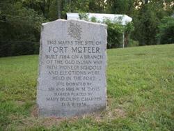
"It is known that Robert McTeer came to survey the land, slept under a beech tree by a spring about where the McTeer marker is, went back and reported it would be a good place to live. So there three families [Bogles, McTeers and McMurrays] came over before the days of the covered wagon and settled close to each other. They left a good place to buid a home in the wilderness. They had not been there long before it was necessary to build a fort for protection, and records show, Robert McTeer built the first fort in Blount County in 1785."
Blount County
BLOUNT COUNTY lies between the Tennessee River and the great Smoky Mountain, and south of Knox County. It has an area of about 470 square miles, one-sixth of which is mountain land. It is abundantly supplied with water and water power. The principal stream is Little River, which receives the waters of Crooked Creek, Pistol Creek, Nails Creek and Ellejoy. In the southern and western portions of the county are Abram, Nine Mile, Six Mile, Four Mile, Baker and Boyd Creeks. The mineral resources are abundant. In addition to iron and marble, silver and gold are found in paying quantities. The settlement of Blount County was begun in 1785. The first fort or station was established by Robert McTeer. "It stood about one and one-half miles south of Eusebia Church. It soon became the nucleus of an excellent neighborhood of intelligent, worthy, and patriotic citizens, emigrants principally from the valley of Virginia, who brought with, and diffused around them, Republicanism, religion, intelligence and thrift." Among those who located in the vicinity were the BOGLES, McCROSKEYS, McCULLOCHS, McGAUGHEYS, McMURRAYS, BOYDS, CUNNINGHAMS, MOORES, TIPTONS, JEFFRIES, CUSICKS and others. Numerous other forts and stations were soon established in various parts of the county. [1]
Two sons, Montgomery and John, died young.[2]
Revolutionary War
This American Patriot is found resting in the Eusebia Cemetery located in Prospect, Blount Co., Tennessee. He served our nation in the American Revolution in the service of the 8th Company of the 1777 – 4th Battalion, Pennsylvania Militia.[3] (Note: See comments on DAR Ancestor record.[4])
Robert McTeer furnished supplies from his farm at Cumberland County, PA, that included beef and horses to the (PA) militia between 1778 and 1780. He also, served during 1777 as a Captain (8th) co., (4th) Bttn., (PA) militia.[5]
His DAR Patriot Number is listed with his SAR Patriot Number.[6]
Sources
- McTeer, Frances Davis; McTeer – Mateer Families of Cumberland County Pennsylvania, Frances Davis McTeer, 1975.
- Smoky Kin
- U.S., Sons of the American Revolution
- Find A Grave
- 1840 United States Federal Census
- Captain McTeer Waymark
- Goodspeed's History Blount County TN
References
- ↑ Goodspeed's History Blount County TN, Published 1887, Page 828
- ↑ McTeer - Mateer Families
- ↑ Captain McTeer Waymark
- ↑ Daughters of the American Revolution, DAR Genealogical Research Databases, database online, (http://www.dar.org/ : accessed 18 Aug 2022), "Record of Robert McTeer", Ancestor # A076514.
- ↑ Sons of the American Revolution
- ↑ Sons of the American Revolution
- Militia Officers Index Cards, 1775-1800, shared by Fold3.com
Note
I applied to DAR in early 2014, using Robert McTeer as my Revolutionary War Ancestor. All of my application was approved, except for the missing birth and death records of my 2nd great-grandparents. Robert McTeer is in the DAR records, and accepted by them. J. Salsbery
Is Robert your ancestor? Please don't go away!
 Login to collaborate or comment, or
contact
 the profile manager, or
ask our community of genealogists a question.
Sponsored Search by Ancestry.com
DNA Connections
It may be possible to confirm family relationships with Robert by comparing test results with other carriers of his Y-chromosome or his mother's mitochondrial DNA. However, there are no known yDNA or mtDNA test-takers in his direct paternal or maternal line. It is likely that these autosomal DNA test-takers will share some percentage of DNA with Robert:
It may be possible to confirm family relationships with Robert by comparing test results with other carriers of his Y-chromosome or his mother's mitochondrial DNA. However, there are no known yDNA or mtDNA test-takers in his direct paternal or maternal line. It is likely that these autosomal DNA test-takers will share some percentage of DNA with Robert:
-
~1.56%
Karen (Coy) Smith
 :
AncestryDNA, GEDmatch A005106 [compare]
:
AncestryDNA, GEDmatch A005106 [compare]
-
~1.56%
H. Pearson :
AncestryDNA, GEDmatch T328851 [compare], Ancestry member Citereh2000
+
Family Tree DNA Family Finder, GEDmatch T328851 [compare], FTDNA kit #B59228
-
~0.78%
Karen (Walsh) Wyman :
23andMe, GEDmatch EA4429960 [compare]
-
~0.78%
Jennifer (Smith) Avedissian :
AncestryDNA, GEDmatch T919759 [compare]
-
~0.78%
J. (Pearson) Salsbery :
AncestryDNA, GEDmatch A020540 [compare], Ancestry member Citereh2000
+
Family Tree DNA Family Finder, GEDmatch A020540 [compare], FTDNA kit #B54446
-
~0.39%
Joseph Wilcox :
AncestryDNA, Ancestry member spacejoe35
Have you taken a DNA test? If so, login to add it. If not, see our friends at Ancestry DNA.


Comments
Leave a message for others who see this profile.
There are no comments yet.
Login to post a comment.
Featured National Park champion connections: Robert is 13 degrees from Theodore Roosevelt, 20 degrees from Stephanus Johannes Paulus Kruger, 14 degrees from George Catlin, 14 degrees from Marjory Douglas, 15 degrees from Sueko Embrey, 16 degrees from George Grinnell, 25 degrees from Anton Kröller, 16 degrees from Stephen Mather, 23 degrees from Kara McKean, 14 degrees from John Muir, 16 degrees from Victoria Hanover and 24 degrees from Charles Young on our single family tree. Login to find your connection.
M > McTeer > Robert Montgomery McTeer
Categories: Patriotic Service, Pennsylvania, American Revolution | Cumberland County Militia, Pennsylvania Militia, American Revolution | NSDAR Patriot Ancestors | NSSAR Patriot Ancestors