Llangadog, Carmarthenshire One Place Study
- Profile
- Images
Location: Llangadog, Carmarthenshire, Wales
Surnames/tags: One_Place_Studies Wales
Contents |
Llangadog, Carmarthenshire One Place Study

Name
Llangadog is a village and community located in Carmarthenshire, Wales. It was also known as Llangadock in the past. It is a Welsh name meaning Church or Parish of St Cadog.
Geography
- Continent: Europe
- Sovereign State: United Kingdom
- Country: Wales
- County: Carmarthenshire
- GPS Coordinates: 51.938808, -3.883317
- Elevation: 52 metres
History
There have been settlements in this area since at least the Bronze Age.
Kings and princes of Ceredigion had a royal hall (a llys) located to the north of the village from the 6th-9th centuries. Castell Meurig was built on or beside this site at an unknown time but prior to 1160. It was a motte and bailey castle which is mentioned in the Pipe Rolls for 1160 and is recorded as destroyed in 1209 - burned by sons of Gruffydd.
The village was unusual insofar as it was not built on the outskirts of the castle, rather it formed around the church of St Cadog.
Population
From the censuses:
| 1841 | 1851 | 1861 | 1871 | 1881 | 1891 | 1901 | 1911 | 1921 | 2011 |
| 2605 | 3055 | 2777 | 2830 | 1911 | 1730 | 1579 | 1588 | 1548 | 1311 |
The current focus is on those who were resident in the village on the night of Sunday 2 April, 1911 when the census was recorded. At that time there was a travelling circus located in the village and as well as the tents and caravans, many of the performers were staying in the local inns. It was called Taylor's American Circus
The profiles on the category page are the individuals who were born, lived, married or died in Llangadog and also those who were associated with it in other ways such as visiting during times of the censuses.
Notables
- David Griffiths - Christian missionary and translator in Madagascar.[[2]]
Name: Mathew Williams Date of birth: 1732 Date of death: 1819 Gender: Male Occupation: landsurveyor, author, and almanack-maker[?] Area of activity: Engineering, Construction, Naval Architecture and Surveying; Literature and Writing It is known that he lived at Llangadock in 1774 and at Rhos-maen, near Llandeilo, in 1788.
- [[3]]
Places of Interest
Places of Worship
- St Cadog's Church on Church Street is medieval in origin with a 14th century tower extensively restored in 1889. It sits in a curvilinear churchyard at the north end of the village. [1]
- Seion Baptist Chapel on Walters Road was built in 1909 to replace the original chapel.
- Gosen Welsh Calvanistic Methodist Chapel, Station Road was originally built in 1770, and rebuilt three times. The existing building from 1907 was to the design of architect George Morgan of Carmarthen in the Lombardic/Italian Sub-Classical style of the gable entry type. This chapel is now privately owned.
- Providence Welsh Independent Chapel is located on the southern edge of the village on the road to Brynamman. It was built in 1840 and enlarged in 1883 to the design of architect Thomas Thomas of Landore.
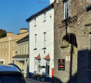
Inns and Hotels
- Telegraph Hotel
- Red Lion
- Black Lion
- Castle Hotel
- Carpenters Arms (now The Goose and Cuckoo)
Sources
- Llangadog on Wikipedia
- Llangadog Community Website
- Genuki Carmarthenshire Families
- Vision of Britain


- Login to edit this profile and add images.
- Private Messages: Contact the Profile Managers privately: One Place Studies Project WikiTree and Jutta Beer. (Best when privacy is an issue.)
- Public Comments: Login to post. (Best for messages specifically directed to those editing this profile. Limit 20 per day.)