- Profile
- Images
Location: Whenuahou Island, Southland, New Zealand
Surnames/tags: One_Place_Studies Southland New_Zealand
Contents |
Whenua Hou, Southland One Place Study
Name
The island has been known as Passage Island and Pegasus Island in the past but more often it is referred to as Codfish Island. It also has the dual name of Codfish Island/Whenua Hou.
Geography
- Continent: Oceania
- Country: New Zealand
- Region: Southland
- GPS Coordinates: -46.783333, 167.633333
- Elevation: 153.9 m or 504.9 feet
History
There was a sealing gang at Waikoropupu/Sealers Bay on Whenua Hou in 1809 and other sealers and flax-traders were living in Maori villages around Foveaux Strait by 1810-13. Sealers' huts, with Maori and Pakeha, were recorded at Sealers Bay in 1823 and again in 1827 when English adventurer John Boultbee visited. Traditional accounts vary as to which chief assigned the use of the island to European sealers and their Maori wives and children, prompting a new name for the island - Whenua Hou, New Land. It had earlier been called Kanawera, after a prominent Ngati Mamoe chief.
One traditional account says that Chief Tukete, who was based at Pa Putatara, near Rakiura's Ruggedy Mountains and in sight of Whenua Hou, allocated the island to sealers and their partners about 1805-06. More commonly, traditional accounts say it was the Foveaux chief, Honekai, who died about 1815, or Tupai, who was near death in 1823. Another early 19th-century chief, Te Whakataupuka, succeeded Honekai as the highest ranking rangatira in Murihiku, and he also is said to have supported the mixed-race settlement of Whenua Hou. These fragments of evidence allow the possibility that sealers with Maori families could have been living at Whenua Hou between about 1805 and 1813, especially if the arrangements were made by Honekai.
Initially, the settlers were relatively few in number. The revival of sealing in southern New Zealand in the 1820s brought about a substantial increase in the size of the settlement, especially from about 1826. Whenua Hou would come to be recognised as the first planned settlement of Europeans and Maori anywhere in New Zealand.
In pre-European times the island had been known to Maori as a maritime way point, a stepping stone and staging post for parties of muttonbirders going by boat from Murihiku to the titi or muttonbird islands off the southwest coast of Stewart Island/Rakiura. Their purpose: the seasonal harvest of the young of countless sooty shearwaters. What came to be mapped as Sealers Bay was known then as Te Whanga Waikoropupu, a name that suggests how the surf can cause the inshore waters to "boil up". Here, though, a short distance beyond the breakers, is safe anchorage as the sandy seabed close to shore gives way to deep water. At the western end of the bay, a beautiful bush-clad and tannin-stained small river called Waituna meanders serenely to the sea.[1]
Forgotten Islands of the South says "Historians consider that the Maori chief, Tukete, was the founder of the colony."
Population
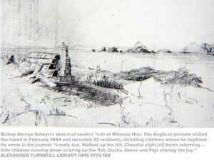
Some 33 Pākehā men, at least 24 Māori women and more than 40 children lived there at various times between about 1823 and 1850. The men were sealers and sailors who had abandoned various gangs or ships, and in some cases were residing with Māori partners and causing disruptions in villages around Foveaux Strait.
For Ngāi Tahu leaders, the solution was to set aside a safe haven where the Māori women could live with their Pākehā partners: a "new land", whenua hou. The sealers had already named this Codfish Island "on account of the number of fish around it ... and the shape of their heads".[2]
While it was probably the earliest permanent settlement of Pākehā in southern New Zealand, the legacy of the Sealers Bay community is felt most strongly in the Māori world. During the 1840s its members gradually dispersed to other localities around Foveaux Strait and Otago.
The children from these early communities produced much larger families than did contemporary Māori, rapidly expanding the size of the mixed-race cohort and transforming the composition of the southern Māori population. Today, as the scholar Atholl Anderson notes, "the descendants of each of the founding Māori mothers at Whenua Hou number in the thousands, and together include most of southern Māori as a whole".[3]
A report in the Wellington Independent in 1846 says "Codfish Island...is now deserted, the residents having lately shifted to Smoky Cove."
Sources
- ↑ https://www.odt.co.nz/lifestyle/magazine/new-lands-storied-history
- ↑ https://www.stuff.co.nz/national/117697061/the-bay-where-mori-and-pkeh-cultural-traditions-overlapped - Saved on Wayback Machine
- ↑ Pākehā Settlements in a Māori World: New Zealand Archaeology 1769-1860, by Ian Smith. Published by Bridget Williams Books, November 2019.
See also:
- https://www.odt.co.nz/lifestyle/magazine/new-lands-storied-history - Saved on Wayback Machine
- https://medium.com/a-maverick-traveller/whenua-hou-codfish-island-and-the-few-k%C4%81k%C4%81p%C5%8D-left-43d465372ecf - Saved on Wayback Machine
- Whenua Hou - A New Land: The story of Codfish Island was published in 2019 by the Department of Conservation, in association with the Whenua Hou Committee and with financial support from the Ngai Tahu Fund.
- Pākehā Settlements in a Māori World: New Zealand Archaeology 1769-1860, by Ian Smith. Published by Bridget Williams Books, November 2019.
- Early Days of the Foveaux Strait by Lloyd Esler.
- Middleton, Angela. Two Hundred Years on Codfish Island (Whenuahou): from cultural encounter to nature conservation. Southland Conservancy: 2007. https://www.academia.edu/944430/Two_Hundred_Years_on_Codfish_Island_Whenuahou_From_Cultural_Encounter_to_Nature_Conservation, accessed 1Apr 2023
- Login to edit this profile and add images.
- Private Messages: Contact the Profile Managers privately: One Place Studies Project WikiTree and Kylie Fowler. (Best when privacy is an issue.)
- Public Comments: Login to post. (Best for messages specifically directed to those editing this profile. Limit 20 per day.)


