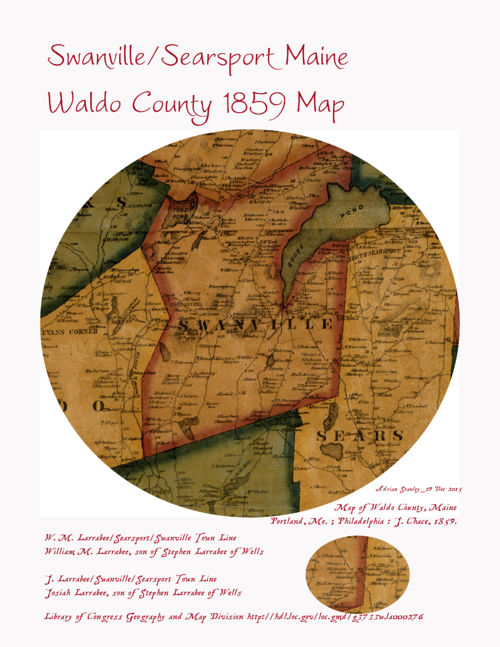
In this image:
-
Stephen Larrabee Jr.


-
Josiah Ames Larrabee


-
William M. Larrabee


-
Enos West


-
Stephen Francis Larrabee


-
Lorenzo W Small


-
Mary Ann (Nichols) Larrabee


-
Job Larrabee


-
Ann (Merithew) Larrabee


-
Margarett A (Smith) Harvey


-
Jeremiah C Merithew


-
Barzilla Dwelley


-
John Seekins Jr.


-
Sarah J (Seekins) Smith


-
Mary E (Rowe) Seekins


-
Joshua West


When: 1859.
Uploaded: 29 Dec 2015 by Adrian Stanley.
Comments: 2, WikiTree Popularity: 1.
Original digital image: 3162 x 4092 pixels. Adobe Photoshop CS4 Windows software. Dated 2015:12:29 12:56:15.
LARRABEE LARRABEE LARRABEE WEST LARRABEE SMALL NICHOLS LARRABEE LARRABEE MERITHEW LARRABEE SMITH HARVEY MERITHEW DWELLEY SEEKINS SEEKINS SMITH ROWE SEEKINS WEST

This image is open for viewing but you need to be logged in to edit the details. Please login here.

The eastern town line between Swanville and Searsport was where the settlement or homestead of the Larrabee family, was located. Stephen Larrabee of Wells owned a large homestead, most of it was on the Swanville side of the town line [W M Larrabee house on the map is Stephen Larrabee's house]. The deed descriptions indicate ownership of a strip of land [Swanville] opposite his home down to Cain's Pond.
Stephen Larrabee's house was on the Searsport [side of the town line. See W M Larrabee.
Near W M Larrabee, a little South on the Swanville side of the town line see J. Larrabee, as Josiah Larrabee
At the 4 O'clock position on the Map see About 4 houses down from the R in Sears [Searsport, Maine] see J. Larrabee. I beleive this is Job Larrabee.
edited by Adrian Stanley
Title Map of Waldo County, Maine / Contributor Names Chase, J. Kelsey, D. Davison, D. H. Rease, W. H. Created / Published Portland, Me. ; Philadelphia : J. Chace, 1859.