This page has been accessed 1,644 times.
Welcome to Cattoosa County, Georgia !
History/Timeline

|
| Anna Ruby Falls.
|
- 1805 The Cherokee and Creek Indians signed treaties with the United States, which culminated in building a Federal Road across land that would later become Catoosa County. This extended from Athensto Gainesville, Dawsonville, Tate, Jasper, and Ringgold, Georgia. At Chatsworth, the Federal Road split with one part going to Knoxville, and the other to Varnell, Ringgold, Ross's landing and further to Nashville. Parts of this road can be seen. [1] [2]
- 1805 the Federal Government cut a road through the Cherokee Nation, which extended from Athens to Gainesville, Dawsonville, Tate, Jasper and Ringgold.
- Mission schools were at Spring Place near Dalton and Chatsworth. Teachers who taught the Indian children, kept notes on the Cherokee life. A Cemetery of the Brainerd Mission is located behind the East Gate Shopping Center.[1]
- 1807 Colonel Elias Earle and workers were traveling to the beginning of Chickamauga Creek and the Tennessee River to build an iron furncace when Cherokee Indians drove them away. [3]
- 1830 Georgia legislature approved a survey of its Cherokee territory, then authorized the lottery commission to divide the land for settlers. [2]
- Nov 24, 1832 - South Carolina passed an ordinance of nullification, was threatening secession if the US government tried to collect tariff duties. General Scott was posted off shore near Charleston and ordered Major Samuel Ringgold to assist with fighting a fire in Charleston, which helped stop further volatile reactions.[2] [3]
- 1838 The last of the Cherokee indians were removed from the region by state and federal authorities on the "Trail of Tears". Chief Richard Taylor, Chief of the Chickamauga District of the Nation lived near the corner of The Old Federal Road, who journeyed to Washington for his people. He led 1 of 12 groups of the Cherokees westward, ending as a leader of the Cherokees in Oklahoma.[1][2]
- 1846- Ringgold, Georgia, the county seat was settled.. Ringgold was named for an officer killed in the Mexican-American War (1846-48), Major Samuel Ringgold, who died fighting in the Battle of Palo Alto. [2][3]
- 1847 James Gordon built the Gordon-Lee Mansion in Chickamauga, which became a hospital during the Civil War.. Then James Lee purchased the property. Today the home is a bed and breakfast. Entrepreneurs in Catoosa such as John Gray built the Western and Atlantic Railroad from Dalton, extending it to Chattanooga. John Gray started a 2nd railway from Harrison, Tennessee, however the Civil war interrupted this project. Near Peavine Valley cross ties may be seen as well as the cuts and land fills..[1]
- 1849 Within 2 years, the Railway, the Western and Atlantic Railroad was built and it passed through Ringgold. Ringgold, Georgia was one of the busiest train stops between Atlanta and Chattanooga, Tennessee. [2]

|
| Catoosa County map with surrounding counties
|
- 1847-1849 Work began on Old Stone Church, east of Ringgold. By 1849 a Presbyterian congregation finished the building of the church. The original altar and pews of the church, which today houses a Civil War museum, are still intact.[2]
- 1849 the Western and Atlantic railway (locally called the "State Line") came through Catoosa County and Ringgold Depot was built.. A town grew around Tunnel Hill, Georgia. finished the railway and built the completed the Ringgold Depot. Troops under James Longstreet arrived here to fight at Chickamauga [2]
- 1850- The Western and Atlantic Railroad was the center of action. First the Railway entered the county, extending connections from Chattanooga, Tennessee through Georgia. A year later, Ringgold, Georgia became the county Seat... [3]
- Dec 5, 1853 saw Catoosa county being formed by the Georgia legislature from parts of Walker and Whitfield counties. The meaning of the name in Cherokee language meaning "between two hills". The county was named for Catoosa Springs, named for a Cherokee chief. Before white settlement the Cherokees used the springs for medicinal purposes. During the Civil War (1861-65), the springs were the site of a Union encampment and several Confederate hospitals were located there, and in 1864 troops skirmished in the area.[2][4][3]
- Dec 6, 1853 Originally part of the Cherokee Indian lands, Catoosa County was created from land of Walker and Whitfield counties. as a county The name is derived from the Cherokee word "catoosa," meaning "between two hills."[5]
- 1854 - Ringgold became the county seat one year after the county was created. It was named for Major Samuel Ringgold (d 1846) of the Mexican War, Battle of Palo Alto. [5]
- Ringgold, Georgia was originally named Taylor's Crossroads due to an inn owner who ran the inn on Old Federal Road in Catoosa County. President James Monroe spent the night of May_26, 1819 in the inn. [3]
- 1856 Catoosa County's first courthouse was built in Ringgold, a 2-story brick structure. Following this the Masonic lodge masons of the area received permission to build a 3rd story for a Masonic meeting hall. Whitman-Anderson House was constructed. It became a Union command headquarters during the Battle of Ringgold Gap of 1863. [2]
- 1861 Catoosa sent 2 representatives to the secession meeting in Milledgeville. One voted to secede but the other did not vote... The medical authorities for the Confederates set up general hospitals behind the lines located in 39 Georgia cities and towns. Some only were at a specific location a short time. hough many of them remained at a particular location for only a short time.[6][1]
- The Great Locomotive Chase

|
| The General, the Great Locomotive Chase
|
- 1862 - Due to the Western and Atlantic Railroad, Catoosa was a target of the Union Army. The Great Locomotive chase passed Ringgold Depot April 12, 1862 and ended north of the station The Great Locomotive Chase passed Ringgold Depot.[3]
- Apr 12, 1862 Union soldiers were heading for Chattanooga, Tennessee. They raided into northern Georgia. It is known as the Great Locomotive chase. They used a spy, James Andrews and 22 Union Ohio troops. This event lasted 7 hours, and the result was military failure, known as the Andrews Raid.. [7]

|
| General, close up, Locomotive Chase.
|
- Andrews raiders and spy James J. Andrews sneaked behind Confederate lines to Atlanta, where they boarded the northbound train hijacked a northbound locomotive the General at Big Shanty (Kennesaw), where they uncoupled most of the cars and raced northward. On the way they destroyed track, bridges, and telegraph lines, and bridges with the intent to knock out the Western and Atlantic Railroad (carrier of Confederate supplies). [7]
- At about 6 a.m. on April 12, 1862, the Andrews raiders steamed out of the Big Shanty depot aboard the locomotive the the General. They first thought the thieves were Confederate deserters. Pursuit began immediately by Railroad men (Murphy and Fuller) on foot, then another train. By 1:00 PM the General ran out of steam 2 miles north of Ringgold. The railroad men (Southerners), on the Texas were close behind them. The Confederates and Railroad men rounded up all the raiders. Andrews and 8 men were tried as spies and executed in Atlanta.[7]
- Andrews Raid
- Great Locomotive Chase
- 1861-62 Catoosa prepared for the War. A general hospital was in Savannah, Georgia and there were general hospitals in Atlanta. [6]
- 1862 The county provided 6 companies of Infantry and 1 Calvary Company. Ringgold became a hospital town. The courthouse was used for a hospital, as well as hospitals in the Inman House, Baptist Church, Catoosa Springs and Cherokee Springs (2000 hospital beds. Injured were shipped in by railway from Kentucky and Tennessee. Additional buildings and houses housed the hospital staff, such as Kate Cummings and Fannie Biers.[1]
- During the Battle of Chattanooga, Union commander Ulysses S. Grant ordered Joseph Hooker to advance on Bragg's retreating army. Bragg chose Patrick Cleburne to guard the rear of the company.. Cleburne made his stand at Ringgold Gap, between the Stone Church and Ringgold Depot. There Cleburne defeated the Union Hooker's 20th Corp in a battle where the Union army outnumbered the Rebels 4:1. [8][3]https://en.wikipedia.org/wiki/Battle_of_Chickamauga Major Gen. Rosecrans commanded the army of the Cumberland which invaded Southern Tennessee and Catoosa county, Georgia. the Confederates of Tennessee were commanded by Gen. Bragg. The name came from Chickamauga Creek in NW Georgia.[9]
2nd Regiment Tennessee Cavalry

|
| map showing Chickamauga
|
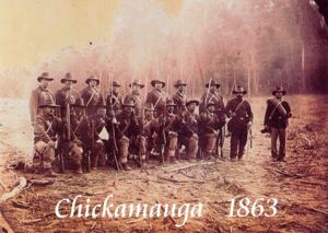
- Battle of Chickamauga was fought in Catoosa and Walker Counties, between the Union and Confederate forces. This Confederate victory, was the second most deadly after the Battle of Gettysburg with 34,000 casualties.
- 1863- Union general William S. Rosecrans intended to hit the Western and Atlantic railways south of Ringgold, to destroy Braxton Bragg's Georgia supply line. Bragg withdrew from Chattanooga and struck the Union forces at Lookout Mountain as they emerged from the gaps to protect the railroad. [3]
- Sept 19, 1863 - The offensive against the Confederates and the Union began with a Union offensive in southeastern Tennessee and northwestern Georgia Category: Battle of Chickamauga was fought in Walker and Catoosa County. This was a Confederate victory, as the 2nd high casualties after the Battle of Gettysburg. [3]
- 1863 Maj Gen. Rosecrans led the 40,000-man Union army of the Cumberland southward toward Chattanooga. They intended to surround Chattanooga and cut off Gen B Bragg and the Army of the Tennessee.

|
| Battle of Chicamauga
|
- Bragg moved the army from Chattanooga to Chickamauga Creek to connect with 30,000 reinforcements. When the Union infantry blocked their way, Bragg’s army crossed the creek. Two generals formed a strategy for a retreat back to Chattanooga. Thomas led the Union lines that night northward. They stopped to have breakfast near a farm. Thomas had news there were some enemy in the woods and sent men to fight. This battle covered a 4 mile area.
- Sept 19, 1864, the fight continued in freezing conditions.The dead and wounded were lying in the fields. One union man lay there for almost a week, with his leg mortifying before dying.
- Sept 20, 1863 Bragg led a dawn attack. Then The Union reorganized and Rosecrans thought there was a gap, thus he moved his men which did create a real gap in the Union army line. The Confederated pushed 1/3 of the army off the field.. This was a Confederate victory.[10]
- 1862-65 During the Civil war, other battles were fought in Catoosa County near Tunnel Hill railroad tunnel in Whitfield County. Confederates defended their territory from Union soldiers. General Sherman used the county as the assembling point for his Atlanta campaign in 1864, gathering more than 100,000 Union soldiers there before marching on Atlanta.[2]
- 1862-65 The Old Stone Church in Ringgold was a hospital during the Civil War for troops on both sides of the conflict. The original altar and pews of the church, which today houses a Civil War museum, are still intact.- Courtesy of Catoosa County News[2]

|
| The Old Stone Church
|
- Field hospitals traveled with the armies.. These were used to treat (triage) although probably the sick and wounded soldiers prior to sending ones needing more care to the general hospitals located behind the lines a distance from the front. Staff for the general hospitals varied due to the bed capacity. They would include surgeons, assistant surgeons, pharmacist, supervisors, nurses, matrons, cooks, and laundresses. Some staff members were soldiers, some were female, some were hired slaves.[6]
- Kate Cumming, Scottish nurse, came into Georgia with the Army of Tennessee as a hospital matron. She kept a journal that was published. It was called "A Journal of Hospital Life in the Confederate Army". [6]
- Aug, 1862 Dr. Stout became supervisor of the Army of Tennessee hospital located at Tunnel Hill, Ringgold, and Dalton, Chattanooga and Atlanta. [6]

|
| Marker for old Stone Church
|
- 1862 - Capture of Andrews Raiders battle in Catoosa County. [2]
- Feb, 1862 - after the fall of Nashville, not many "safe" hospitals behind the lines north of Chattanooga. Off and on a couple were in Knoxville.Since they were on railways the hospitals took in wounded soldiers able to trave by train when they were evacuated from the field hospitals[6]
- 1862-65 Civil War the church was a hospital for both the Confederate and Union forces.
- 1862 - Ringgold Depot is one of the few antebellum railway depots existing today. It was used for transportation of Confederate soldiers during the Civil War.[5]
- 1863 - Union and Confederate troops battled near Chickamauga Creek, in numbers of men, it is known as one of the bloodiest battle. [5]

|
| Battle of Chicamauga
|
- Built at the turn of the century, Fort Oglethorpe was home to the 6th Cavalry and was considered to be the best Cavalry post in the United States. In 1946 the military installation was sold by the government to a local group of civilians as a ready made town.
- Fort Oglethorpe was a calvary post, serving as home to the 6th Cavalry. Today the original Cavalry post buildings on Barnhardt Circle are used as private homes.[5]
- 1863 Macon City Hall (built 1837) , was a field hospital during the Civil War as well as the temporary state capitol during the final months of the war. [6]
- 1862-64 Due to the advancing Union Army coming south from Chattanooga, Col Wilder burned part of Ringgold. General Longstreet brought part of the Army of northern Virginia to thwart the Union advancement at Chickamauga. Longstreet unloaded at Catoosa Platform since the Confederates had burned the bridges in Ringgold Gap. The confederates had a victory at Chickamauga, needed 4 days to gather up the wounded from the battle for evacuation to Ringgold and hospitals further south. [1]
The Confederates retreated back through Ringgold Gap after the “Battle of Missionary Ridge.” Gen. Patrick Cleburne and 4,000 men held off the Union while the Confederates regrouped at Tunnel Hill and Dalton. [1]
- 1863 the Army of Tennessee under Braxton Bragg retreated to Chattanooga. Chattanooga and 7-8 towns of north Georgia were evacuated. Dr. Stout relocated his hospitals to towns south and west of Atlanta, with a plan to mobilize the hospitals. His plan included transporting the patients to a hospital that was not moving, after which the staff would pack all supplies and moved to another location in local buildings or tents. He felt all towns for the hospitals needed to be on a railway, as trains were the most comfortable for the patients.
- When transportation collapsed, the hospitals surrendered or were captured by Union forces. They still continued serving the needy soldiers.
- 1863 Whitman-Anderson House was used as the Union command headquarters during the Battle of Ringgold Gap. Battle of Chicamauga in Catoosa County very near Ringgold. [2]
- 1864 General Sherman used Catoosa county for the gathering point when he was invading Atlanta in 1864. He brought over 200,000 Union soldiers in Catoosa County as a central point before advancing the troops to invade Atlanta, Georgia.[2][1]
- 1865 Prior to Sherman Catoosa County forest had been virgin forest land when the Indians left 1838. After Sherman, the poor forest was a burned out wasteland. A lot of the citizens gave up and moved to Arkansas, Texas etc. At one time there was 1 family and a woman in the town. Depression extended from 1865 into the 1900's. [1]
- 1866-1870's Catoosa County suffered the same pattern other southern counties economies suffered following the Civil war and the Reconstruction. Railways had been destroyed. Without slave labor, plantations could not operate. Owners were forced to abandon them or turn them over to sharecroppers, some were African Americans working the same as had been done as slaves, except they worked as sharecroppers and were free.
- The railways were repaired after the destruction of the war, then small farmers and sharecroppers could resume growing crops for shipping to market.[2]
- 1890 The U.S. Congress established Chickamauga and Chattanooga National Military Park to commemorate the Battle of Chickamauga. It was the 1st national military park established in the National Parks System. The first fortress was Camp George Thomas where they trained soldiers for readiness prior to the Spanish-American War of 1898. By 1903 Fort Oglethorpe replaced the smaller Camp Thomas[2]
- Plans for a flume line through Ringgold Gap around White Oak Mountain, which would yield waterpower for many mills. Ringgold, Georgia was the north part of the Railway.. Wagons would line up, filled with wheat ready to be shipped to the East Coast. The mill located in Trion manufactured cloth, delivered it to the depot, and returned with more bales of cotton for cloth, using mules to pull the wagons..[1]
- 1898 Cubans rebeled against Spain. The battleship Maine blew up in Havanna harbor. So US Congress authorized the president to stop the conflict.. Congress authorized 200,000 volunteers to be called up to be stationed at Camp George H. Thomas in Chickamauga Park. The officers were inexperienced, and sanitary conditions were bad, resulting in an outbreak of typhoid fever. Not many troops went overseas to the war.[1]
- 1902 -Oglethorpe, Georgia After manufacturing began, this was an economic boost for the county.It was named for the founder, James Edward Oglethorpe one of the founders of Georgia. This grew out of Chickamauga Post, a U.S. military base originally was within the boundaries of the Chickamauga and Chattanooga National Military Park.. Chickamauga-Chattanooga National Military Park is in Fort Oglethorpe, which is oldest and largest park. 9 historic sites on 8,000 acres were Civil War battle grounds.Eight historic areas constitute approximately 8,000 acres of Civil War battlegrounds. The Sixth cavalry began in Fort Oglethorpe.[5][2]
- Oct 23, 1917 Hessian Flies were discovered in a wheat field in Catoosa County which can be prevented by burning the fields after harvesting. By December, local wheat was 89% infested. [3]
- 1917-1918 After Fort Oglethorpe was built 1902, the U.S. Army Medical Department was stationed here, until the 1918 flu epidemic caused many troops to die. German civilians were interned here during WW I just as the Japanese were interned in Oregon during WW II. Their area was where K-Mart is now located and was called the Millionaires Club because many were quite wealthy.[1]

|
| Fort Oglethorpe, view from Chicamauga & Chatannooga Nat. Mil. Park
|
- 1939- The Catoosa County Courthouse, was built in Ringgold and is the county's 2nd courthouse. Designed in the colonial revival style, the courthouse replaced an older one that survived the Civil War.
- 1941-45 World War II saw the Women's Army Corps (WAC were stationed at Fort Oglethorpe. In 1947 Following War War II, Fort Oglethorpe was closed and sold. Fort Oglethorpe was decommissioned and became a private city. many of the Military buildings are still visible. 1949 Fort Oglethorpe was incorporated by Georgia as a city for civilians.[2] [1]
- 1959 In Ringgold Gap excavations for I-75 revealed an Indian village near the S end of Anderson Cemetery dating back to 1000 BC. Artifacts to the state Archeologists Lab in Carrollton, and are now in the Stone Church museum. The Mound Builders and several mounds are still visible in Catoosa County.
- Mar 14, 2002 a dense fog enveloped I-75 and Ringgold, Georgia. Visibility was less than 200 feet. An accident of 2 tractor-trailer trucks finally involved 125 vehicles in a chain reaction.[3]

|
| Tornado- Ringgold
|

|
| Damaged hotel
|
- Apr27, 2011 7 tornadoes struck Cattoosa County. One was EF-5 which hit downtown Ringgold and other tornadoes struck Eastern states Apr 25-Apr28.[3][4]
- Today Many Union soldiers camped at Catoosa Springs, Cherokee Springs and even Ringgold. Today people with metal detectors find Minnie balls, cannon shells, and railway ties frequently.[1]
Government Offices

|
| 1856 Catoosa Courthouse, Ringgold
|
1st county courthouse was built in 1856. [3]

|
| Catoosa County Courthouse
|
2nd County County Courthouse, current
Geography
- Location located in the upper northwestern part of the U.S. state of Georgia.
- Population 2010 , the population was 63,942.
- County Seat- Ringgold.
- Size total area of 162 square miles (420 km2), of which 162 square miles (420 km2) is land and 0.3 square miles (0.78 km2) (0.2%) is water.
- Sub-basin all of the county is in in the Middle Tennessee-Chickamauga sub-basin of the Middle Tennessee-Hiwassee basin.
- Catoosa Springs, or Coffee Springs. The springs are an alkaline-saline mixture with calcic-magnesic, chalybeate and sulphuretted.
Adjacent counties
- Hamilton County, Tennessee (north)

|
| Catoosa map and Georgia
|
- Whitfield County (east)
- Walker County (west)
Protected areas
- Chicamauga &Chatannooga Nat. Mil. Park
- Chattahoochee-Oconee National Forest home of birds such as species of hawk, species of owl, blackbirds, ducks, eagles, sparrows, hummingbirds, geese, and cardinals. Mammalian species that roam in the forest are black bear, shrew, coyote, a variety of bats, squirrel, beaver, river otter, bobcat, deer, weasel, mice, and foxes. Many species of fish and amphibians swim in the streams, as well as various reptiles
- Chicamauga and Chattanooga National Military Park Spanish–American War was a training center for troops in the southern states. It was temporarily renamed "Camp George H Thomas" (union) for a Civil War battle here. The closeness to the major railway at Chattanooga and available large land tracts, was a goo place for troops in training for service in Cuba.
Demographics
In 2000, there were 53,282 people, in the county with a population density of 328 people/sq. mi. The racial makeup of the county was 96.39% White, 1.26% Black or African American, 0.31% Native American, 0.71% Asian, 0.02% Pacific Islander, 0.39% from other races, and 0.93% from two or more races. 1.17% of the population were Hispanic or Latino of any race. In 2010 there were 63,942 people in the county with a population density of 394.3 people/sq. mi. In terms of ancestry, 20.8% were American, 17.6% were Irish, 13.2% were German, and 10.2% were English. The median income for a household in the county was $46,544 and the median income for a family was $54,796. The per capita income for the county was $22,563. About 8.5% of families and 11.2% of the population were below the poverty line, including 14.8% of those under age 18 and 9.0% of those age 65 or over. [11]
- In 1969 I-75, part of the Eisenhower Interstate System, was completed in Catoosa County
- I-75 was built. It has 4 exits for Catoosa County in 3 miles. I-75 connects Atlanta with Chattanooga, Nashville, Knoxville, and Birmingham. The traffic from both Alabama and western Georgia on Hwy 27 meters I-7The last important chapter in our history was the construction of I-75. No one had any idea how it would change the economic picture of the county. Catoosa County has four exits in about 3 miles of interstate and each is a center of economic activity. I-75 also puts us into close contact with Atlanta, Chattanooga, Nashville, Knoxville and Birmingham. Traffic from Alabama and West Georgia from Highway 27 usually enters I-75 at Ringgold by way of Highway 151.[1]
- Catoosa County is part of the Chattanooga, TN–GA Metropolitan Statistical Area.
- According to the 2010 U.S. census, Catoosa County's population is 63,942, an increase from the 2000 population of 53,282.
Highways
| Highways | Highways | Highways
|
| Interstate 75 | U.S. Route 27 | U.S. Route 41
|
| U.S. Route 76 | Georgia State Route 1 | Georgia State Route 2
|
| Georgia State Route 3 | Georgia State Route 146 | Georgia State Route 151
|
| Georgia State Route 401 (unsigned designation for I-75)
|
Schools
- Catoosa County elementary schools: Battlefield Elementary, Battlefield Primary, Boynton Elementary, Cloud Springs Elementary, Graysville Elementary, Ringgold Elementary, Ringgold Primary, Tiger Creek Elementary, West Side Elementary, and Woodstation Elementary.
- Catoosa County middle schools: Heritage Middle School, Lakeview Middle School, and Ringgold Middle School.
- Catoosa County high schools: Heritage High School, Lakeview-Fort Oglethorpe High School, Performance Learning Center, and Ringgold High School.
Cities
Towns
County Resources
- Chicamauga & Chatannooga Nat. Mil. Park

|
| Fort Oglethorpe, view from Chicamauga &Chatannooga Nat. Mil. Park
|
Census
- 1860 --- 5,082 —
- 1870 --- 4,409 −13.2%
- 1880 --- 4,739 7.5%
- 1890 --- 5,431 14.6%
- 1900 --- 5,823 7.2%
- 1910 --- 7,184 23.4%
- 1920 --- 6,677 −7.1%
- 1930 --- 9,421 41.1%
- 1940 --- 12,199 29.5%
- 1950 --- 15,146 24.2%
- 1960 --- 21,101 39.3%
- 1970 --- 28,271 34.0%
- 1980 --- 36,991 30.8%
- 1990 --- 42,464 14.8%
- 2000 --- 53,282 25.5%
- 2010 --- 63,942 20.0%
- Est. 2016 --- 66,398
Cemeteries
Sources
- ↑ 1.00 1.01 1.02 1.03 1.04 1.05 1.06 1.07 1.08 1.09 1.10 1.11 1.12 1.13 1.14 1.15 http://catoosachamberofcommerce.com/PDF/HistoryOfCatoosaCounty.pdf
- ↑ 2.00 2.01 2.02 2.03 2.04 2.05 2.06 2.07 2.08 2.09 2.10 2.11 2.12 2.13 2.14 2.15 2.16 2.17 2.18 https://www.georgiaencyclopedia.org/articles/counties-cities-neighborhoods/catoosa-county
- ↑ 3.00 3.01 3.02 3.03 3.04 3.05 3.06 3.07 3.08 3.09 3.10 3.11 3.12 3.13
- ↑ 4.0 4.1 https://en.wikipedia.org/wiki/Catoosa_County,_Georgia
- ↑ 5.0 5.1 5.2 5.3 5.4 5.5 http://www.catoosa.com/history
- ↑ 6.0 6.1 6.2 6.3 6.4 6.5 6.6 https://www.georgiaencyclopedia.org/articles/history-archaeology/confederate-hospitals
- ↑ 7.0 7.1 7.2 www.georgiaencyclopedia.org/articles/history-archaeology/andrews-raid
- ↑ https://en.wikipedia.org/wiki/Battle_of_Chickamauga
- ↑ https://en.wikipedia.org/wiki/Battle_of_Chickamauga
- ↑ https://blog.fold3.com/the-battle-of-chickamauga/
- ↑ https://en.wikipedia.org/wiki/Catoosa_County,_Georgia
*https://en.wikipedia.org/wiki/Indian_Springs%2C_Georgia