
York County, South Carolina
- Profile
- Images
Date:
[unknown]
[unknown]
Location: [unknown]
Surnames/tags: york_county south_carolina us_history

Location: [unknown]
Surnames/tags: york_county south_carolina us_history
This page has been accessed 1,287 times.

This profile is part of the York County, South Carolina One Place Study.
Welcome to York County, South Carolina Project!
| ... ... ... is a part of South Carolina history. Join: South Carolina Project Discuss: South Carolina |

York County, South Carolina
- Leader of this Project is Paula J
- Coordinator is Mary Richardson
Contents |
History/Timeline
- pre-1540's The Catawba Indian Nation lived in York county region, who had homes located near the creek and river highlands. They hunted, farmed, fished and made pottery. Their influence is still in the region. The Catawba trading path ran from Virginia into York County region which split after crossing the Catawba River.[1]There were a reported 6,000 Catawba Indians when the Europeans arrived.[2] [3]
- Path #1led to the lower Cherokee Villages.
- Path #2 led south to Saluda. Today the crossing and the trail are known as Nation Ford and Nation Ford Road.[1]
- 1540 Hernando de Soto came through York area looking for the fabled gold.[3]
- 1560 - Juan Pardo arrived observing Native Americans (Catawba) living near the Fort Mill area, east of the Catawba River.[3]

|
| logo |
- 1682- South Carolina Province was divided into 3 counties by the legislature:[2]
- Craven County area covered the northern 1/2 of South Carolina plus the southern 1/2 of the current York County.[2]
- 1745's Due to high land prices and rental increases in Pennsylvania, Scots-Irish Presbyterians began to migrate on the Great Wagon Road, through Virginia and North Carolina. When they arrived in the Upcountry west of the Catawba River, the Scots-Irish stayed in York County. These Scots-Irish had the blood and religion affiliations and escaped the hard Ulster, Northern Ireland life for America. Other emigrants, such as Germans, English, Welsh, and French came to the area, but later moved on.[2][3][4]
- 1750's Land grants for the region were issued in Anson, North Carolina..Before 1750 the boundaries between the 2 Carolina's were not settled. Northern part of York was changed from being part of Bladen County, North Carolina to part of Anson County, North Carolina[2] [4]Land grants and deeds were issued in Anson County, NC. [3]
- 1750's Ebenezerville was the earliest settlement, located near the intersection of Herlong and Ebenezer streets. The residents started early cotton plantations and and shipped the bales of cotton through Camden to Charleston. From there, they were shipped the cotton to mills in New England and England for weaving.. At that time most of York county land was considered to be part of North Carolina.. Eventually York citizens decided they might as well build mills and weaving places in York county.[1][4]

|
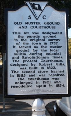
| Old Muster Grounds |
- 1762 Carolina backcountry was ablaze with the migration activity. Mecklenburg County, North Carolina, was formed from western section of Anson County, North Carolina. Mecklenburg, North Carolina contained the current north part of York County. [2][4][3]
- All settlers in the backcountry practiced military drilling after arriving. They were located near Cherokee, Shawnee and Creek natives. Charlestown officials were indifferent to settlers trouble. So they had a local militia to ward off the Indian raids or outlaws. These were called "Beat Companies", containing all able bodied men. They did not have wars, just were there for protection.[3]
- 1768 - Another legislative change the same land of York co. that was included in Mecklinburg, North Carolina became part of Tryon County, North Carolina (included all of North Carolina west of the Catawba River and south of Rowan County, North Carolina.[2][4][3]
- 1772 - at last the boundary between North Carolina and South Carolina was established closer to what we see it today. The area was called the "New Acquisition District extending 11 miles north to South and 65 miles formats to west. [2]
- 1776 the American Revolution in the South began, the northern part (the New Acquisition District) provided the militia which was effective in turning the tide of war against the British. The battles of Williamson's Plantation (aka Huck's Defeat) and Kings Mountain, among others, were fought on York County soil. In the beginning the back country citizens wanted to be on the sidelines and remain neutral if they could be left alone. They felt the war was between Britain and the aristocrats of Charlestown.[3]

|
| Battle of Kinstree. |
- 1780, 81 Revolutionary War battles were fought on York County soil. The backcountry contained an estimated population of more than a quarter of a million. [1][3]
- 1780 The people of York County opposed the Royal authority due to 3 invasions of the region.
- Lt Colonel Banastre Tarleton and his Green Dragoons
- Lt. General Charles, Lord Cornwallis invaded two separate occasions.
- July 12, 1780 The Battle of Huck’s Defeat (or Williamson’s Plantation) was the first British defeat since the fall of Charleston.[1]

|
| Battle of Kings Mountain. |
- Oct 7, 1780 The Battle of King’s Mountain, a battle between British forces and the "Over the Mountain Men of Tennessee" and the British forces, occurred in northwest York County on land that straddles the South Carolina/North Carolina border.[1]

|
| Battle of Kings Mountain |
- May, 1780 Buford's Massacre in Lancaster County. Most of South Carolina capitulated to British rule. But backcountry citizens kept up resistance, being led by William "Billy" Hill, William Bratton, and Samuel Watson.
- 1780 Carolina backcountry population went from zero to a population of 250,000 people who were mostly Scots-Irish Presbyterians. Scots Irish Presbyterians tended to remain in a clannish type of community called "clachans", just as they had been in Pennsylvania and in Ulster, Northern Ireland.Although most were Scots Irish, there were some emigrants of England, Wales, Swiss, French, Germans.[4][3]
- Clachans grouped around the Presbyterian Kirks (meetinghouses). The meetinghouses were forerunners for the church congregations. [2]The oldest are:
- Bethel
- Bethesda
- Beersheba
- Bullock's Creek
- Clachans grouped around the Presbyterian Kirks (meetinghouses). The meetinghouses were forerunners for the church congregations. [2]The oldest are:
- 1782 The American Revolution in the backcountry caused economic hardship. Backcountry residents were Patriots, helping with the defeat of Loyalist forces in the state. After the war these residents shared in rebuilding. [3]
- 1785 The General assembly formally established York County in South Carolina. In the first census of the United StatesYork County was an original county (referred to as the New Acquisition) of South Carolina. Its boundaries stayed the same for a while until 1897.
- 1786 The first steps were done in establishing the county seat. It was to be on the site of Fergus' Cross Roads, named for brothers, John and William Fergus. Six roads met and crossed near the county's center (near Congress and Liberty Streets in York). These were important wagon roads that ran northwestward from York, SC toward Kings Mountain.[3]

|
| York, SC |
- 1790 the county had 6,604 population, but these were not planters. Of 6,604 population, 923 were listed as slaves, of which 9 men owned 25%. [3][2]
- Congregations formed from the clachan. These were within a five-to-ten-mile radius of the meetinghouse, having 20 to 500 families. Thus the church, was the focal point of backcountry society. When new residents arrived they settled near the churches. [3]
- 1800 South Carolina legislature again renamed counties as districts, but did not use it until after 1866. [3]
- May 1809 William D. Martin, a future member of the South Carolina House of Representatives, described the village of York as "Its local situation is pleasant & interesting. The 'scite' is on a plane of some length, near the centre of which is a small eminence, on which is built the Court House, a neat brick building. The private houses also, are principally of brick, & very far excel those usually built in similar places." [3]

|
| Winthrop University,Tillman Hall |
- 1821 Since settlers wanted some education to read the Bible of go to college, South Carolina General Assembly granted Ebenezer Academy corporate status. The school building was the 2nd bolding built in Ebenezerville. This school was a private school at this time.[1][4]
- 1823 - Yorkville population was 441 with 292 white citizens and 149 African Americans. The population of the village in 1823, as recorded by Robert Mills, stood at 441 and included 292 whites and 149 blacks. Mills described Yorkville in 1826: The town was "regularly laid out in squares" containing "8 stores, 5 taverns, a male and female academy, post office, and a printing office, which issues two papers weekly."

|
| York County, SC Presbyterian church. |
- 1840 Yorkville's population was 600; by 1850, Yorkville contained 93 dwellings and 617 inhabitants. Yorkville became a summer resort for low country planters who wanted to escape the malarial swamps of the low country for the moderate climate.1860 the town was 1,300. [3]
- 1841 This new town later was renamed the village of York, or York Court House. It was incorporated and soon was officially Yorkville. All of the original lots were 66 ft X 330 ft. They found a public spring and used by citizens for drinking water and washing clothes.[3]
- 1840- Charlotte and the South Carolina decided to build a railroad from Charlotte to Columbia, SC. The noise and pollution possibilities worried citizens, so the railroads built the track 2 miles east of the community near a rocky area that was a landmark. This was called "rocky hill"[1][3]
- 1848 the Kings Mountain Railroad began laying the tracks between Yorkville and the Charlotte * South Carolina Railroad in Chester.

|
| York County Courthouse, 1918. |
- April 17, 1852 The name for the town, began called Rockhill, having a post office called Ebenezer Depot [1][4]
- 1852- the railway was completed and began operating in the eastern part of the county, the Charlotte & South Carolina Railroad. This provided transportation for products and added jobs.
- 1860 Eastern York District still only had 100 citizens and was a crossroads settlement.
- 1862-65 During the Civil War Some Refugees from the low country came to Yorkville, where Union troops were in their hometowns.
- 1862-65 Civil War - prior to this war, York was one of the more populated districts. Its white male population was 5,500. County men supported the Confederate cause in 14 infantry companies. Some were: Jenkins' Light Infantry, Whyte Guards, Carolina Rifles, Kings Mountain Guards, Catawba Light Infantry, Bethel Guards, Lacy Guards, Indian Land Guards, Palmer Guards, Campbell Rifles, Turkey Creek Grays, Indian Land Tigers, Mountain Guards, and the Broad River Light Infantry. York District had the highest death rate of any county. [3]
- 1865 - One small battle was fought during the Civil War in York District, called the Battle for the Catawba Bridge at Nation Ford. Population and economic growth halted. Yorkville itself had less residents in 1880 (1,339) than the 1860 census showed (1,360). [3]
- 1866 Residents of Rock Hill attended church at Ebenezerville's Presbyterian Church. {ome Grove Academy opened and the Methodist attended semi-weekly services in a school building. The Episcopalian and Baptist attended services in homes of members. [1]
- 1866-1870 after the Civil War local businessmen merchants borrowed to stock their stores. They made a profit, then bought store #2, repaid the loan and bought more stock. After this banks and utility companies opened. Soon Mills opened to process the cotton. This was followed by buggy makers, tobacco processors, machine shops, a cannery, grist mills, and a furniture maker.[1][3]
- 1868 - Another South Carolina state Constitution of 1868, all districts were renamed as counties. Therefore, York District became York County once again (as it was from 1785 to 1800).
African Americans attend church meetings in Brush Arbors. They opened Hermon Presbyterian Church. [1][4][3]

|
| map |
- 1872, a plan was to build an extension of the Kings Mountain Railroad. The Carolina Narrow Gauge Railroad Company was incorporated in North Carolina, and the Chester & Lenoir Narrow Gauge Railroad in South Carolina in 1873. The Chester & Lenoir constructed a narrow gauge railroad from Chester through Yorkville to bring rail service to western York County. On the other side of the county, the Charlotte & South Carolina Railroad's bridge over the Catawba River was replaced and allowed the Rock Hill vicinity to begin economic recovery.[3]
- 1880 Rock Hill schools were organized. It had 2 public schools: Rock Hill Academy (1854-88) was mostly for boys and had another name, Pine Grove Academy for boys and Pinneapolis Academy for girls started 1875. [1]
- 1880s Herman Presbyterian Church, and Episcopal Church school for African Americans were established[1]
- Cotton market improved due to technology advances. Rock Hill Cotton factory was built in York County. It was steam powered, which extended the cotton industry. Rock Hill Buggy Company, founded by John Gary Anderson, began and became Anderson Motor Company, the first automobile manufacturing company in the south.
- 1880-1895 Rock Hill experienced profound growth, its population rising from 809 to over 5,500. Grade schools were needed and money was raised.In 1901, 38 school districts were in the county with 102 building.[1]

|
| Glencairn, Rockhill, SC. |
- 1890s Education for women had increased. D.B. Johnson started a teacher training school, located in Columbia. Governor Benjamin Tillman took up the cause to train women for business and industrial jobs. Tillman and Johnson started the South Carolina Industrial College and the Winthrop Normal College which later became Winthrop University. South Carolina cities all wanted to host the colleges. Rock Hill won the campaign.
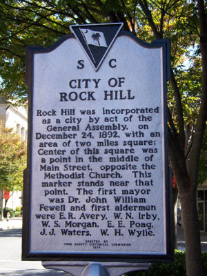
- Jan 7, 1896 the cityof Rockhill began.. [1]
- 1897 a small portion of the northwestern corner of York County was used for Cherokee County, South Carolina.[2][4]
- 1900's Catawba tribal land claims delayed developing some residential and commercial property both in Rock Hill and the general York County. [1]
- Feb 20, 1912 the name changed again to Rock Hill.[1][3]
- 1904 Catawba Dam and Power Plant was built . In 1899 Whitner foundered the Catawba Power Company and with Gill Wylie and Robert Wylie. After completion it took a while to get the power plant working with the dam, due to periodic flooding. By 1911 1 Million textile spindles were powered by this plant.
- late 1920s-mid 1940's York, York County, South Carolina housed several circuses during the winter. 1) Barnet Brothers (originally Ray Rogers circus) of Canada 2) Bennett Brothers Circus wintered in York, SC and used the time to train and prepare new shows. Barnett Bros Circus changed the name to Wallace Bros. were located on E. Jefferson and Trinity Streets., York, SC
- 1993 -Federal recognition of the Catawba Nation land claims were settled.. The Catawba reservation can be found southeast of Rock Hill.[1]

|
| RockHill. |
- This County has an estimated population of 230,500. Peaches, many greenhouse, strawberry and vegetable fields grow in the western area. Communities within York county are Rock Hill, Fort Mill, York, Clover, Tega Cay, Lake Wylie, Hickory Grove, McConnells and Sharon. The Rivers around York are Catawba River on East, Broad River on the West. Both rivers originate in the Blue Ridge Mountains (western North Carolina). The rivers contribute both water for fields, and agriculture, but recreation..

|
| Catawba River |
- Currently York County is located in the north-central part of South Carolina, which is called the Piedmont. The Piedmont has a varied terrain ranging from rolling hills to the southeast to steep hills in the northwest part of the county. North Carolina is on the North, Chester County on South, Lancaster County on East, and Cherokee and Union Counties on West. The broad river is on the west, Catawba River on the East. All of York County is located within the piedmont (a 100 mile belt which extends from sand hills of NE Soutn Carolina to the Blue Ridge Mountains in the NW corner.[3]York County honors its past with several Cultural and Heritage Museums, including Historic Brattonsville, the McCelvey Center and the Museum of York County.[1]
- Currently York County remains a rural type of county. The exception is in the eastern 1/3 of the county which contains Rock Hill, the largest city. It also has Fort Mill, Tega Cay and Lake Wylie which have residential development. The Northwestern section of the county has developed due to the proximity of Charlotte, North Carolina..[4] Some think the history started right before 1776 the Revolutionary War. However by then the county had developed a heritage. [3]

|
| Fort Mill Historic District, Fort Mill, SC. |
KING COTTON AND POPULATION
:
- In 20 short years following the first census, York District had increased in population to more than 10,000 - of which over 3,000 were slaves. As the county's dependence on cotton grew, its dependence on slave labor to produce the crop also grew. These confusing statistics reflect the fact that York County had mostly small and medium sized farms. There were a few large plantations there but were not the norm.[3]
- 1790's the Cotton gin introduction started the county to growing cotton. King Cotton grew, and thus, the numbers of slaves grew. [3]
- 1793 All of South Carolina only produced 94,000 pounds cotton grown mostly in the Sea Islands. [3]
- 1800 the whites were 82.1% of population[3]
- 1811 the backcountry had grown more than 30 million pounds cotton. Cotton changed the farms so that in 1820 40% of the families were slaveholders. [3]
- 1820 white population was 68.6% of total[3]
- 1823 - the Yorkville Pioneer had begun printing.[3]
- 1825 3 post offices were operated in York District: Yorkville, Blairsville, and Hopewell. [3]
- 1839-1860 York District's slaves worked on small and medium farms- not large plantations.
- 1850, York District census showed 15,000 residents with (>40% were slaves). 93% of the work force raised crops versus the United States had 78% average agricultural work force. 13% of York District worked in industry. York District contained 27 post offices. Roads were formed (not paved). Five newspapers were being published: the Patriot, the Whig, the Journal of the Times, The Yorkville Compiler, the Yorkville Miscellany. 1855- the Yorkville Enquirer also began.[3]
- 1860 York district's slaves were few. 70% of farms had < 10 slaves. Only 3% of farms having 50 or more slaves. 20% of farms had <590 acres of land. 23% had 51-100 acres, and 53.9% had 101-500 acre farms. Average # [3]
- 1861 prior to Civil War, the county population was 21,500 with 50% being slaves.[3]
- 1870'sYork county did not develop the plantation-based economy similar to counties of the coastal area. Reconstruction changed everything, including the agriculture. Many of York County's large property owners sold part of the land to small farmers. Many became tenant farmers. The size of the average farm dropped while the # of farms increased. Ignorance of land management caused the soil to become exhausted, as happened in Texas. Soil experts such as during the 1930's, taught farmers to avoid a single crop, but to rotate planting crops. Cotton was a money maker, but ruined the land. [3]
- 1900 York County has continued the growth begun in 1880. Cotton declined in 1920's and the Great Depression of 1930's. 1921- was South Carolina's peak cotton crop to be harvested in 1921, then cotton declined. Factors 1) Boll weevil, 2) Soil Erosion resulting from over use. 3) New Deal helped farmers 4)1940's and 50;s trend to larger farm operations, reducing the small farms. but in 1938 cotton production was 10% of the economy even though 49% of the land was planted in cotton. Now farmers grow crops such as soybeans. Small farms have decreased. The textile industry continued to develop. Rock Hill became the hub of this industry, while mills blossomed throughout the county.
Government Offices
|
|
| Old Muster Grounds Marker |
|
|
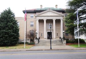
| York County Courthouse, 1918. |

|
| York County Courthouse. |
Geography
Size- total area of 696 square miles (1,800 km2), of which 681 square miles (1,760 km2) is land and 15 square miles (39 km2) (2.2%) is water.
- Location - York County can be found in the north-central portion of South Carolina. It is bordered by North Carolina on the North, Chester County on South, Lancaster County on East, and Cherokee and Union Counties on West. The broad river is on west, Catawba River on the East. All of York County is located within the piedmont (a 100 mile belt which extends from sand hills of NE Soutn Carolina to the Blue Ridge Mountains in the NW corner.. the Piedmont has varied terrain which ranges from rolling hills in SE to steep hills in the northwes
- Locale -York County is in north-central South Carolina, near the North Carolina border.
- Boundaries - Broad River on west, Catawba River on East
- Topogragraphy - All of York County is within the Piedmont region.
- Type- York County is located in the north-central part of South Carolina, which is called the Piedmont.
- Terrain -The Piedmont has a varied terrain ranging from rolling hills to the southeast to steep hills in the northwest part of the county. North Carolina is on the North, Chester County on South, Lancaster County on East, and Cherokee and Union Counties on West. The broad river is on the west, Catawba River on the East. All of York County is located within the piedmont (a 100 mile belt which extends from sand hills of NE Soutn Carolina to the Blue Ridge Mountains in the NW corner.
- Trees, Vegetation -Heavily wooded in rural areas, retains rural characteristics in western part.
- Metroplex - part of the greater Charlotte metropolitan region and includes Rock Hill, the county’s largest city, as well as the smaller cities of Tega Cay and York and the smaller towns of Clover, Fort Mill, Hickory Grove, McConnells, Sharon, and Lake Wylie.
- Trees, vegetation -heavily wooded in rural areas, supporting the timber industry
- Crops - Cotton, was the dominant crop but not as much as in the past.
- Mountains - Largest mountainHenry's Knob, mountain and site of a former open-pit mining operation for the world's largest deposit of kyanite . Mountain altitude - 1,120 ft (340 m) above sea level.
- Location of mountain -near the North Carolina border and the town of Clover.
- US Environmental Protection Agency - mine is Superfund Alternative Site for acid mine drainage and contamination of groundwater.
- All Mountains -
- Henry's Knob
- Joe's Mountain
- King's Mountain
- Nanny Mountain
- Soil -
- Climate York County has a humid subtropical climate, Hot humid summers, cool, Dry winters.
- Precipitation -does not vary greatly between seasons.
- Temperature - July is the hottest month, with an average high temperature of 91 °F (33 °C) , low-71°F (22 °C). The coldest month of the year is January, high temperature is 53 °F (12 °C) and low is 33 °F (1 °C).
- Hottest temperature in York County, Rock Hill, 106 °F (42 °C), on August 21, 1985, Coldest was Rock Hill at -6 °F
- Location York County is a county located in the north-central section of the U.S. state of South Carolina.
- Largest City- Rock Hill.
Adjacent counties
- Gaston County, North Carolina - north

|
| York county within South Carolina |
- Mecklenburg County, North Carolina - northeast
- Lancaster County - east
- Chester County - south
- Union County - southwest
- Cherokee County - west
- Cleveland County, North Carolina - northwest
Protected areas
- Catawba River and Broad River offer recreational opportunities.
- Sporting venues
- Parks provide more recreation
- located in the County, provide residents with ample recreational opportunities. York County *Cultural and Heritage Museums
- Historic Brattonsville
- McCelvey Center
- Museum of York County.
- Kings Mountain National Military Park
- Kings Mountain State Park
- Historic Brattonsville
Demographics
- The county is served by one interstate highway, I-77
- Near airport, Charlotte/Douglas International Airport.
Schools
- York County, SC schools
- Rock Hill Schools
- Best Public Schools, York County
- York County has four public school districts. District One serves central and western York County, including the town of York; District Two serves northern York County and the town of Clover; District Three serves the City of Rock Hill and southern York County; District Four serves eastern York County and the town of Fort Mill.
- As of the 2010 census, the population was 226,073. Its county seat is York, South Carolina,
- York County is the home of :
- 1) York Technical College
- 2) Clinton Junior College
- 3) Winthrop University, in Rock Hill
Highways
- Interstate 77
- US Highway 321
- US Highway 21
- South Carolina 122
- SC 161
- SC Highway 5
- SC Highway 51
- SC Highway 901
- SC Highway 72
- SC Highway 274
- SC Highway 4
- York County is part of the Charlotte-Concord-Gastonia, NC-Rock Hill SC Metropolitan Statistical Area.
Cities
Towns/Census Des Places/Uninco Communities
- Fort Mill
- Clover
- Hickory Grove
- McConnells
- Sharon
- Smyrna (partly in Cherokee County)
- Holy Islamville
- Hopewell
- Ogden
- Red River
- Smith
- Tirzah
Ghost town
- Ebenezer, former town
- Filbert, former town
- Oakdale, former community
- Balloon, former community
County Resources
- Winthrop University, York County, SC
- SpeakEasy Jazz Night Jazz
- Rock Hill Community Theatre Musical, York County
- The Real Christmas Story, NarroWay Theatre & Conference Center, York County
- Museum of Western York County
- Winthrop Wind Symphony I Ensemble Series
Census
- 1790 --- 6,604 —
- 1800 --- 10,250 55.2%
- 1810 --- 10,032 −2.1%
- 1820 --- 14,936 48.9%
- 1830 --- 17,790 19.1%
- 1840 --- 18,383 3.3%
- 1850 --- 19,433 5.7%
- 1860 --- 21,502 10.6%
- 1870 --- 24,286 12.9%
- 1880 --- 30,713 26.5%
- 1890 --- 38,831 26.4%
- 1900 --- 41,684 7.3%
- 1910 --- 47,718 14.5%
- 1920 --- 50,536 5.9%
- 1930 --- 53,418 5.7%
- 1940 --- 58,663 9.8%
- 1950 --- 71,596 22.0%
- 1960 --- 78,760 10.0%
- 1970 --- 85,216 8.2%
- 1980 --- 106,720 25.2%
- 1990 --- 131,497 23.2%
- 2000 --- 164,614 25.2%
- 2010 --- 226,073 37.3%
- Est. 2016 --- 258,526
Cemeteries

|
- Rootsweb Cemeteries
- York county Cemteteries, SC
- FindaGrave York County Cemeteries
- Cemeteries of York County, South Carolina
- York County was outstanding for the large cemeteries, with most graves marked by stone monuments, adjoining the Presbyterian churches. These picturesque churchyards, at Bethesda, Bethel, Sharon, Bethany, Beth-Shiloh, Olivet, or Smyrna, would still inspire Thomas Grey to write more elegies. On the other hand one finds in York County fewer private family burying grounds.
Sources
- ↑ 1.00 1.01 1.02 1.03 1.04 1.05 1.06 1.07 1.08 1.09 1.10 1.11 1.12 1.13 1.14 1.15 1.16 1.17 1.18 1.19 1.20 http://www.ychistory.org/ychistoryintro.php
- ↑ 2.00 2.01 2.02 2.03 2.04 2.05 2.06 2.07 2.08 2.09 2.10 2.11 https://en.wikipedia.org/wiki/York_County,_South_Carolina#Pre-colonial_and_colonial_history
- ↑ 3.00 3.01 3.02 3.03 3.04 3.05 3.06 3.07 3.08 3.09 3.10 3.11 3.12 3.13 3.14 3.15 3.16 3.17 3.18 3.19 3.20 3.21 3.22 3.23 3.24 3.25 3.26 3.27 3.28 3.29 3.30 3.31 3.32 3.33 3.34 3.35 3.36 3.37 3.38 3.39 http://www.carolana.com/SC/Counties/york_county_sc.html
- ↑ 4.00 4.01 4.02 4.03 4.04 4.05 4.06 4.07 4.08 4.09 4.10 4.11 4.12 https://www.rootsandrecall.com/fairfield-county/files/2012/09/Chapter-A-Early-York-County.pdf
- http://www.cheraw.com/about_cheraw.php?About-Cheraw-Town-History-Cheraw-the-American-Revolution-8
- https://www.yorkcountygov.com
- http://www.visityorkcounty.com
- York County History, Wikipedia
- https://www.sciway.net/hist/indians/catawba.html
- Rootsweb Cemeteries
- York county Cemteteries, SC
- FindaGrave York County Cemeteries
- Cemeteries of York County, South Carolina
Images: 14


Collaboration
- Login to request to the join the Trusted List so that you can edit and add images.
- Private Messages: Contact the Profile Managers privately: Mary Richardson and Paula J. (Best when privacy is an issue.)
- Public Comments: Login to post. (Best for messages specifically directed to those editing this profile. Limit 20 per day.)
- Public Q&A: These will appear above and in the Genealogist-to-Genealogist (G2G) Forum. (Best for anything directed to the wider genealogy community.)
Comments
Leave a message for others who see this profile.
There are no comments yet.
Login to post a comment.